Study sites in cropland
Study sites in grazing land
Study sites in forests
Traditional crops (1950 to 1985)
| Authors: | Artemio Cerdà, Félix González-Peñaloza |
| Coordinating authors: | Constantinos Kosmas, Giovanni Quaranta |
| Editors: | Alexandros Kandelapas, Jane Brandt |
Editor's note 20Mar14: Source D132-10.2.1
Assessment of natural, economic and social capitals
| Natural capital | |
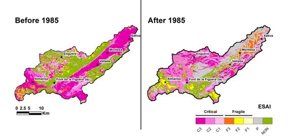
| Assessment | Most of area is characterized by a low soil capital index (more than 38 % of territory), closely followed by moderate capital (28.28%). Both types of soil capital are mainly located in the valley slopes. Soils of high and very high capital values (30 and 2%, respectively) are found at the bottom of the valley.
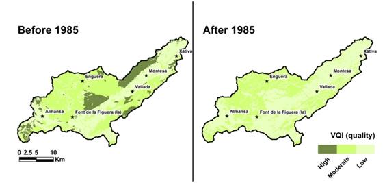
The spatial distribution of the climate capital index (CCI) shows that practically the whole watershed is characterized by low climate capital (87 %), except the northern part of the valley (13 %), which is high. The water resources are distributed for irrigation by a network of canals, wells and watermills that cover all the floodplain area, but the quality of water resources during the period is unknown. Historically, the dominant type of natural vegetation in the watershed includes Pinus sp woodlands, shrubs and pastures. Agrarian surfaces, on the other hand, increase significantly from the mid-20th century as fruit tree orchards expand and unproductive areas and traditional Mediterranean cultivations shrink (e.g. olive groves, cereals and vineyards). However, the increase of crops and the absence of environmental planning cause the loss of several environmental values because the major part of the area is prone to erosion by wind and runoff due to the lack vegetation cover. Most of the vegetation capital has moderate to low index values, 45 and 40 % respectively. The low values cover all the agriculture areas (citrus (5 %), olive groves (9 %), fruits (1%) and arable lands (17 %)) both in the floodplain and southern part of the study site.
|
| Critical functions | The regulation of hydrological processes has been determined using the Revised Universal Soil Loss Equation (RUSLE) model. The floodplain, around 60% of the area, is characterized by very high hydrological process (classified as Null classes of potential erosion). High and very high values of soil loss erosion are found in both valley sides, especially in areas covered by pasture and shrubs and cover 4% of the area. Significant Pearson correlation (r) between soil loss erosion by hydrological processes and topography (LS factor) as land use is found. Slope LS factor is better correlated with soil erosion (r=0.7; p=0.05) than by land use (r=0.4; p=0.05).
|
| Critical variables | - |


| Economic capital | |
| Assessment | The economy of the study area follows the same trend as the whole region of Valencia. In addition, the Cànyoles watershed is under economic influence of the municipality of Xàtiva based (bus network, commercial activities, education services, healthcare and establishment numbers). Until 1960s the economic activity is developed in the mountain areas (foods, raw materials, fuel (charcoal and firewoods).
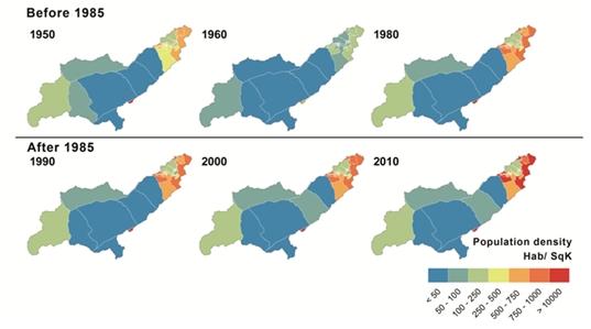
In 1950, half the labour force in Xàtiva municipality is employed in agriculture by 1991 this reduces to 10%. Mechanisation of agricultural activities contribute to the migration of the rural population mainly to the coastland and an increase in part-time work. Husbandry is almost completely abandoned before 1970. In contrast, industrial activity in Xàtiva employs around 50% of the total population.
|
| Critical functions | Crop production is estimated using statistical data provided by regional databases and by surveys and interviews with farmers. Olive grove production has never been enough to supply domestic consumption. The mean estimated relative production of a rainfed olive grove is around 0.80 kg ha-¹yr-¹. Vineyards, located mainly in the middle-southern study site, produce 3,500 kg ha-¹. Cereals fields, located in flats areas on soils with moderate to deep depth, showing a relatively low production of 2,000 kg ha-¹yr-¹. Citrus orchard producing between 12,000 and 18,000 kg ha-¹. |
| Critical variables | - |

| Social capital | |
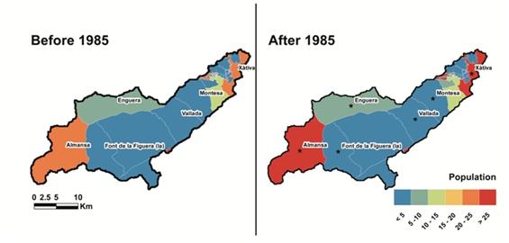
| Assessment | The main concentration of the population is around the municipality of Xàtiva as the village itself is located on the only natural path between the Peninsula massif and the coastland (Valencia City). In addition, a deep and rich soil, formed from river nutrient inputs, enables rich farming, enhanced by a warm climate. This climate, together with adequate input from the farmers, allows the cultivation of highly profitable crops such as the citrus orchards.
The population is concentrated around the most profitable crops, industrial areas (e.g. vehicle dealers, pharmaceutical products) and the main educational and medical centers. Population dynamics are typical of the Mediterranean mountain areas, with steady abandonment of the countryside for the first 60 years of the 20th century but, unlike others areas of Spain, the areas are not totally abandoned because of the proximity of both the coast and Valencia, one of the major cities of the Spain. This fact favours the development of industrial activities that keep the population in rural areas.
|
| Critical functions | - |
| Critical variables | Slow critical variables during the period include land policies, land use change and soil depth reduction. All three were influenced by pre-democratic laws about land management with often brutal effects on the environmental because of the encouragement of irrigated crops, and - therefore - the exploitation of the continental waters and use of agriculture machinery. In the study site, small size plots (over 80% of the plots have less than 5 hectares), developed much more intensive management, replacing traditional rain-fed cultivation, as Citrus orchards, due to the demand of foreigners markets. The fastest variable during this period was social, namely depopulation. |
Main LEDD problems and responses
Despite of the extension of citrus, which is associated with lack of vegetation cover for the most part of the year, soil erosion rates are relatively low because new orchards are in flat areas such as the floodplain of the Canyoles River. Nevertheless, requirements for irrigation and fertilizer increase. Intensification is often more pronounced in small farms (90% of farms are under 5 hectares).
Decline in agricultural income leads to the reduction of the number of farmers as they seek employment in the factories surrounding Xàtiva or other urban and industrial areas, mainly along the coastline. Despite the richness of the crops, the economy primarily comes from industrial activity. Depopulation of mid-mountain agriculture from the mid-20th century areas causes land abandonment and a progressive recovering of the natural vegetation. As a result of the study site experiences overall moderate erosion (29%).
Rainfed crops are replaced by irrigated lands in the flat areas but equally important is the transformation of the mountainsides by terraces. Early citrus orchards occupy the coastline but quickly expand to marginal land, taking water from wells, as the high price of fruit and the relatively low demands for labour make it an attractive investment. The establishment of a grove on marginal land usually involves the extensive levelling of slopes. However, in the absence of quality soils, soil often has to be imported. In 1977 citrus covers more than 50% of Xàtiva – La Costera lands.
Policy context
AK: to check that implementation, impacts and effectiveness of selected policies are discussed in this text. Look at D142 to see if there is any additional information.
The main policies in effect are related to the improvement of agricultural production. The "colonization" laws refer to implementation or expansion of irrigated lands, as well as the replacement of unproductive areas by crops, in order to improve the productivity and to attract to young population to the new areas.
Properties of the system
AK: to check if there is any further relevant information in D133
Natural capital: Not different from above.
Economic captial: Not different from above.
Social capital: Not different from above.
Socio-ecological resilience
AK: to be added, source: D133
Socio-ecological fit of the dominant response to LEDD
AK: to be added, source: D133