Study sites in cropland
Study sites in grazing land
Study sites in forests
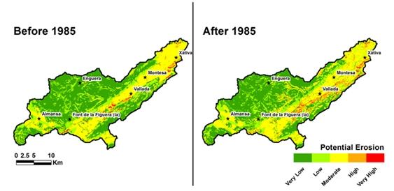
Implementation of CAP and extension of citrus orchards (1985 to date)
| Authors: | Artemio Cerdà, Félix González-Peñaloza |
| Coordinating authors: | Constantinos Kosmas, Giovanni Quaranta |
| Editors: | Alexandros Kandelapas, Jane Brandt |
Editor's note 20Mar14: Source D132-10.2.2
Assessment of natural, economic and social capitals
| Natural capital | |
| Assessment | Most of the valley has a low or moderate or low soil capital index. Soils with high and very high capital values are found in the valley bottom.
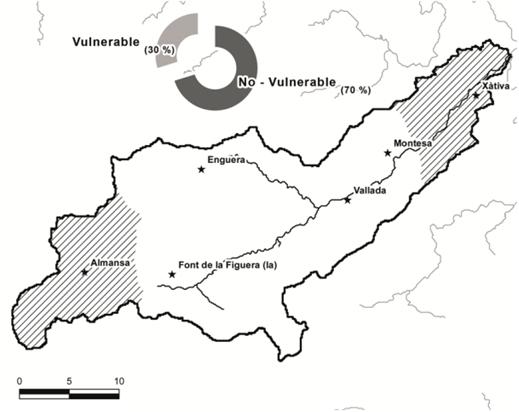
Water capital is very low because, during the last decades, water pollution due to agricultural activities has affected soils with low organic matter content and there has been low rainfall. According to the GIS coverage obtained from the national government areas vulnerable to land degradation coveri about 30 % of the total area.
Vegetation is moderate to low vegetation quality. Moderate quality vegetation covers over 40 % of the total area, occupying both the flood plain and a significant part of the both valley sides. Low quality vegetation covers about 60 % of the total area and is mainly in the valley bottom. |
| Critical functions | According to the hydrological processes determined by RUSLE, over 37% and 16% of the study site is classified as null and low classes respectively; mainly located in the floodplain as flat areas. Very high (6 %), high (4.6%) and moderate (15.3%) classes are mainly located in the mountain areas. Soil depth reduction in recent decades is generally lower than 0.5 cm yr-¹, (89% of the area).
The conversion of agricultural land to new citrus orchards has destroyed the terraces developed for previous rainfed crops. After one year of cultivation, there is a crusting on the topsoil (82 %) due to the use of fertilizers and herbicides and to the lack of a vegetation cover to protect the soil from raindrop impact. Vegetation covers about 4% of topsoil and stoniness (7.29 %), rills (5.24 %), gullies (0.69 %) and cliffs (0.56 %) have all appeared. As a result, regulation of hydrological processes is being affected: in citrus orchards, runoff is faster than in other plotareas s due to the emerging ponding. Runoff is over 50% in citrus orchards. |
| Critical variables | Both traditional and current agricultural practices have caused great disturbances. The reduction of soil depth by intensive land use affects the storage of water and nutrients in soils. Soil crusts and stoniness are increasing runoff. This is especially significant in hilly areas throughout the study site.
Soil depth reduction is the major (slow) critical variable. Soil depth reduction varies between under 0.5 cm in plains areas and on soil protected by vegetation (89 %) to over 1 cm in steepest areas occupied by crops (12 %). Land use is another fast critical variable: olive groves (47%), cereals (35%) and vineyards (28%) are replaced by irrigated crops, especially by citrus orchards (now 32%) in the lowlands. This intensification of agriculture contributes to a great increase in productivity over the past 30 years, but it is also accompanied by significant degradation. The continuous application of chemicals exceeds the storage capacity of the soils and the contaminants have found their way to river and groundwater. There is are large amounts of nitrates in the groundwater. In addition, the quick expansion of irrigation technologies (e.g. drip irrigation or use of powerful water pumps) cause the overexploitation of aquifers and serious reservoir depletion and groundwater imbalances. |

| Economic capital | |
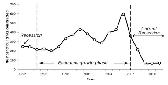
| Assessment | Economic growth is mainly supported by construction, where employment increases by 20% between 1994 and 2006. National and regional policies are facilitated by low interest rates and bank credit, fuelling increases in home prices and real estate speculation.
The location quotient shows that both the construction and the tertiary activities are the most important activities in recent times. There is a dramatic growth in the number of buildings constructed in the whole the watershed, especially during the economic growth phase.
|
| Critical functions | - |
| Critical variables | - |
| Social capital | |
| Assessment | The population is mainly located in areas surrounding the municipality of Xàtiva, and in the municipality of Almansa, a change of around 20%. The population are attracted by the tertiary and construction sectors. Population density ranges between 28.6 inhab. Km-² and over 100.000 inhab. Km-². |
| Critical functions | - |
| Critical variables | - |
Main LEDD problems and responses
Responses in the Cànyoles watershed after the implementation of the CAP are primarily negative: problems of land degradation are increasing. Modernization and intensification processes clearly aimed at maximizing agricultural production have caused new forms of exploitation that have exceeded the carrying capacity of the territory, depleting and polluting natural resources, such as soil and water. The advent of democracy and the adoption of the CAP policies included some landscape protection. However, these policies have also caused the expansion of highly intensive farming in marginal areas. Abandoned crops cause high soil erosion rates during the first years of land abandonment but these rates decline as vegetation recovers. The decline of the rural lifestyle causes negative effects on the environment. The abandonment of pastures and disappearance of small farms because of their inability to compete in the market, cause changes in land use, provoking landscape transformation.
Policy context
AK: to check that implementation, impacts and effectiveness of selected policies are discussed in this text. Look at D142 to see if there is any additional information.
Main policies in effect are those related to rural development, namely regulation (EEC) 2078/92 on agricultural production methods compatible with the requirements of the protection of the environment and the maintenance of the countryside and Regulation (EEC) No 2328/91 on improving the efficiency of agricultural structures.
Properties of the system
AK: to check if there is any further relevant information in D133
Natural capital: -
Economic captial: -
Social capital: -
Socio-ecological resilience
AK: to be added, source: D133
Socio-ecological fit of the dominant response to LEDD
AK: to be added, source: D133