Study sites in cropland
Study sites in grazing land
Study sites in forests
General description of Zhang Jiachong SES
| Authors: | Xiaoping Chen, Bo Hu, Honghu Liu, Feipeng Ren, Zhigang Wang, Pingcang Zhang |
| Editors: | Alexandros Kandelapas, Vassilis Koutsoukos, Jane Brandt |
Editor's note 15Feb13: Source D131-6.3
Location
Zhang Jiachong watershed is located in Zigui County of the Hubei Province, China. It is populated by a total 176 of families (620 people, 248 labourers)
Climate
The watershed belongs to the subtropical continental monsoon climate zone, with an annual average temperature of 18°C and annual precipitation of 1181.1 mm, with rainfall concentrated from May to September.
Topography, soils and hydrology
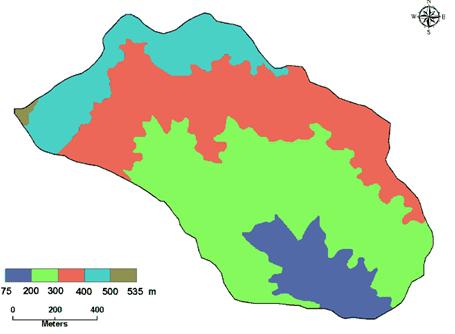
The terrain is hilly with a lowest elevation of 175 m, and a highest elevation of 532 m. Around 75% of the territory has an altitude between 200-400m. Slopes are generally facing South-west (22%), West (20%) and South (20%) The prevalent slope gradient is 35-60% (41% of the area).
 |
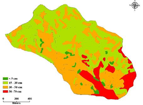 |
Zhang Jiachong watershed soil is mainly silica soil developed by the parent material of granite.The most common soil depth class is 15 to 50 cm (85%).
The minimum water level of the Zhang Jiachong river is 65.08 mm. Maximum water level (recorded in July) is 65.15 mm. Maximum flow discharge is more than 25 m³/s (July) but generally less than 5 m³/s. Sediment yield concentrates between May and September and exceeds 1kg /(m³.s) in July and August. Sediment yield is zero in the other months.
Ecosystems and land use
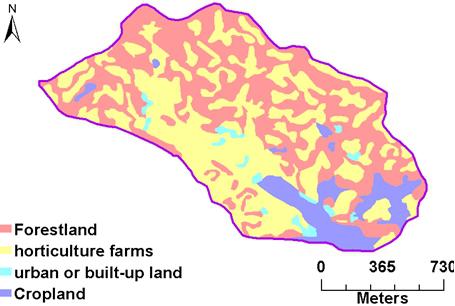
Zhang Jiachong small watershed is a terrestrial ecosystem, including 4.63 hm² of forestland, 14.29 hm² of horticulture farms, 44.11 hm² of urban or built-up land and 98.96 hm² of croplands. The most common vegetation coverage is between 50% and 100% (88.3% of the watershed area). The rest vegetation cover is ranging between 30% and 50%.
 |
 |
Population, employment and income
Population is increasing from 569 in 1989 to 620 human beings in 2010, with a clear majority of female inhabtants. Population density is 473 people/km², concentrated in the village of Chenjiaba. The birth rate is higher than the death rate, the dependency ratio is stable and net immigration is positive.
Both gross income and total expenditure are increasing, but the former remains higher than the latter.
Zhang Jiachong has a village hospital but no school. Education level is relatively low.
33% of the population are farmers. Unemployment is estimated at 27% but that includes children and old men.
The village office in Chenjiaba manages all Zhang Jiachong watershed issues for the farmers.
Particular LEDD in Zhang Jiachong
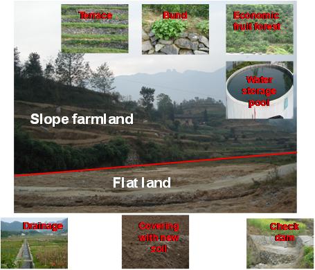 |
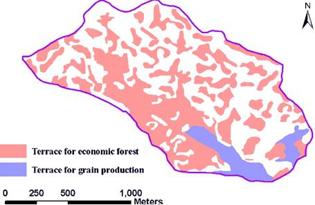
Major land uses in 2010 were forestland (4.63 hm²), horticulture farms (14.29 hm²), urban or built-up land (44.11 hm²) and cropland (98.96 hm²). Terraces cover 82.16ha, including 70.96 ha for economic forest and 11.2 ha for grain production. Sheet erosion and gully erosion affect 0.97 km² or 60% of the total area. the modulus of soil erosion in this area is 6705 t/(km².a). Soil loss is the main factor for land degradation. The drivers and biophysical impacts of soil loss in Zhang Jiachong small watershed are the same as Zigui county. |
Comprehensive control measures have been adopted covering an area of 88.7 hm² drastically improving land production capacity. By converting 25.5 hm² sloped farmland to terrace, 5.6 hm² to economic fruit forest, 10 hm² to tea garden, 5.6 hm² to soil and water conservation forest and 5.6 hm² to closing hillside for erosion control. Measure and works also include: 3 water storage pools, 1 pond, 8 check dams, 20 sediment deposition pools, 1.1km creek drainage, 4.0 km field drainage and installation of 130 biogas digesters.
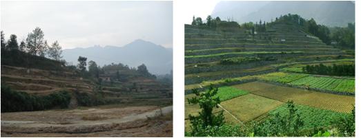 |
While soil and water loss is over 80%, the total amount of soil erosion has declined from 6705 t/km².a to 1050 t/km².a. Farmer’s income and life quality is improving. After applying comprehensive control measures, net income per farmer has tripled. |