Study sites in cropland
Study sites in grazing land
Study sites in forests
General description of Timahdit SES
| Authors: | Ahmed El Aich |
| Editors: | Alexandros Kandelapas, Vassilis Koutsoukos, Jane Brandt |
Editor's note 5Mar13. Source D231-3.3. One page introduction then rest of section available for download
 |
Location and history The Ait Arfa du Guigou tribe is a fraction of the Beni Mguild Federation. The tribal areas of the Beni Mguild are located in the central portion of the Middle Atlas. The Beni Mguild came from the High Atlas Mountains, seasonally migrating to the Middle Atlas since the 16th century before finally settling in the 19th century. Four ethnical units compose the Beni Mguild; the Ait Arfa du Guigou located in the area of Timahdit, the Irklaouen in Azrou, the Ait Abdi in Ain Leuh and the Ait Sgougou located in El Hamman. The research focuses on the Ait Arfa du Guigou, constituting the rural community of Timahdit, stretches over an area of 617 km² in the Center-East of the Middle Atlas. The study area is covered by forests (14,100 ha), agricultural land (12,500 ha) and unused lands (4,100 ha). |
Climate
Study area climate is Mediterranean-mountain: semi-arid, with hot summers and cold winters. The wet season coincides with the cold season, with 65 to 80% of the precipitation occurring between November and March. Temporal distribution of precipitation is bimodal, peaking in November and April. Some precipitation is in the form of snow (45 days yearly average). Mean PPT is about 403 mm and mean temperature ranges from 17 °C to 32 °C.
Precipitations are concentrated in winter and spring. They decrease from an average of 800 mm at Jbel Hebri (1900 mm) to reach 400 mm at Timahdit village. The region is characterized by cold winters (-2.5 °C min. average, +9.8 °C max. average). Summers are very hot (31 °C max. average).
Average annual humidity is 55.73% (higher during winter). Average of solar radiation is 0.40 Kw/m², varying between seasons. Wind velocity averages 6.08 m/s. Average evapotranspiration for the period 2006-2011 was 3.08 mm/day ranging from 1.6 mm/day (December-January) to 5.8 mm/day (June).
Geology, topography, soils and hydrology
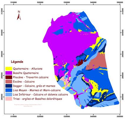
The northern part of the study area includes the Azrou plateau owing its surface features to Quaternary volcanism: cinder cones punctuating a surface covered with basaltic flows. On the Guigou Plain near Timahdite, outcrops of Jurassic limestone and Jurassic dolomite provide evidence of basalt overlying limestone. Along its southwestern edge, the Azrou Plateau abuts a zone of limestone domes and synclines. On either side of the gap at Timahdite, the front consists of abruptly upthrust bench of Cretaceous limestone. Some of these benches are overlain by pyroclastic material. South of the area of Aguelmem rise mountainous domes of Jurassic dolomite. These domes end abruptly at the exposed, upthrust edge of a narrow, overlying bed of Jurassic limestone. This formation gives way quickly to a zone of Cretaceous calcic marne hills which reach 2087m.
Elevation in the study area ranges from 1500 m to 2450 m.
 |
 |
 |
Two major types of soils exist in the study area: those derived from basaltic parent material and those derived from limestone and dolomitic parent material. The former type includes: Brown soils found in depressions, Vertisols, Lithosols and vitric andosols. The latter type includes: Red Mediterranean soils and Renzines. While many of these soils, especially those of basaltic origin, are quite fertile, most are shallow and extremely stony. The soils of the pastures are generally of good quality, dark brown in color, and contain considerable humus. Pastures are located on basaltic band overlying calcareous or dolomite parent material. With regard to soil texture, the two main categories are clay dominant soil with dark color (70%) and limon soil with red color (20%). Soil texture, structure, color, and horizon delimitations are fairly uniform throughout the area.
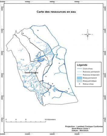
The major permanent stream in the area is the Oued (river) Guigou entering the at the Southeast corner and flowing North to Timahdit and then east. Its major tributaries are the Oued Bouangar and large springs near the Ighzafen and Ait Haddou settlements. Ephemeral flows from springs such as Aghbalou N'Troumit and from ephemeral streams such as Tighza supplement in the spring. Permanent lakes include Aguelmem Tidouit and Aguelmem, near the Ighzafen settlement. Many small springs dot the terrain in the South. In general, stock water resources are abundant in the South but extremely limited in the North.
Ecosystems and land use
The main types of vegetation found in the study site are:
- Forests (Atlantic cedar, green oak, juniper often with with Scorzonera pygmea understory)
- Grass and shrub land (Genista pseudopilosa, Artemisia mesatlatica, Artemisia herba helba, Scorzonera pygmea)
- Shrub grassland (Thymus zygis grassland, Bupleurum spinosum grassland, Mixed shrub grassland, Heliunthemum croceum grassland, Spiny shrub and annual grassland)
Land devoted to agriculture is about 12,500 ha for the Timahdit area (25% of Ifrane agriculture). Agriculture is mainly practiced in farms rather less than 50 hectares. Agriculture is oriented toward livestock feed. The main crops are cereals (56% of production), forages (24%) and fallow (17.2%). Cereals are cropped both in rain fed and irrigated fields. Forages are mainly cropped in rain fed zones. Land devoted to legumes cropped for human consumption purpose represents 10% at the province level.
In the Middle Atlas, there are about 3.6 million small ruminants with an average of one head per hectare. The number of cattle is about 120,000. Sheep breeding dominates Ifrane province. Herd management is oriented toward subsistence rather than optimization of the production. Economic performance is weak. The majority of farmers, despite the overexploitation of resources, has a minimum subsistence level and lives in difficult conditions (isolation, lack of equipment).
Land tenure
Currently the Ait Arfa du Guigou Perimeter is used by four fractions: the Ait M'Hamed, Ait Hcine ou Hand, Ait Ben Hcine and Ait Ben Yacoub. The Perimeter contains 58,780 ha (53% collectively owned, 21% privately owned, 26% state owned forestland). The collective lands of the Perimeter are generally shrub and grassland vegetation types, providing excellent summer pasture, but also commonly used throughout the entire year. Rapid melting of snows and immediate shooting up of vegetation makes winter grazing possible. This constant and excessive grazing is a major range problem leading to over-utilization and depletion of forage resources. By law, all people born into the four sub fractions have legal grazing rights to the area.
Regulation of land use generally takes place according to traditional law (Orf: customary law and Islamic law for access to resources), despite radical changes in institutional regulation of grazing since the French Protectorate. (modern forest code applied by the Forest Service)
Land tenure is pivotal for rangeland management, as rangelands are usually under collective ownership. The group has all the resources necessary for its existence and rights to make agreements with neighbors to gain access to additional resources. Access of members to different resources is managed within the group. Their management is not without problems, related primarily with the abandonment of traditional seasonal enclosures (agdal) and the general reluctance to accept or enforce any limitation to access. Communal pastures tend to be in a state of degradation, often leading to conflict for limited resources, particularly during droughts: grazing conflicts threatening social peace and public order.
Population
The Beni Mguild Berbers have been nomads in the past, but are now settled. Sheep herding remains their main activity and shepherds still live in tents in summer pastures. Beni Mguild society could be characterized as a segmentary society, with every lineage having a council of elders making all decisions. The council made sure that in winter pastures grass should grow sufficiently enough before it was grazed. Such councils still exist in the High Atlas.
The 8 rural communities of Ifrane have a young population, with 39% under 15 years old and 8.5% over 60 years old. Average household size is approximately 6 people.
The village of Timahdit has one public health, four primary schools, one secondary school, and one post office.
Particular LEDD issues in Timahdit
Until 1930, the Ait Arfa du Guigou had no permanent dwellings and few cultivated fields. They were wintering with their neighboring tribes in low lying areas and passing the rest of the year in the mountainous area they inhabit today. To meet domestic consumption, pastors were practicing subsistence agriculture in the most favorable locations. This system was characterized by exploitation of resources by a sparse population and stocking for a rational use of forest and pastoral resources. Seasonal mobility (transhumance) and the practice of «agdal» were the main characteristics of this system, allowing a complementary use of soils.
However, delimitation of collective land, privatization, government policies to settle the Berbers and expansion of agricultural speculations contributed to the transformation of production systems. Moreover, this transformation is also explained by the demographics that resulted in the tripling of the population of these areas in less than fifty years since the 1950s. The increase of the population sided with an increase of land used for agriculture, leading to grazing pressure on the pastures and tensions among pastoralists. Many pastoralists were forced to have their herd grazing the same area continuously.
In parallel with population growth, the number of animals increased significantly despite the gradual reduction of rangelands. This has led to over-exploitation of rangelands and forests. Rangelands are becoming increasingly unable to ensure livestock reproduction.