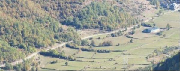
Study sites in cropland
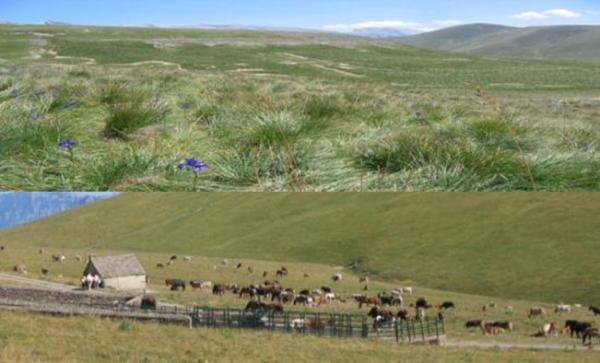
Study sites in grazing land
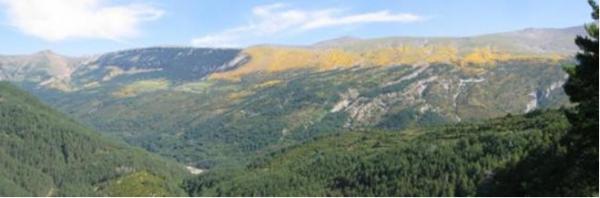
Study sites in forests
Agro-pastoral society (pre 1980s)
| Authors: | Federico Fillat, Ricardo García-González, Maite Gartzia, Paz Errea |
| Coordinating authors: | Concepción L. Alados, Giovanni Quaranta, Rosanna Salvia |
| Editors: | Alexandros Kandelapas, Jane Brandt |
Editor's note 20Mar14: Source D232-2.2.1
Assessment of natural, economic and social capitals
| Natural capital | |
| Assessment | Vegetation capital comprises forest, shrub, dense grasslands, sparse grasslands and meadows and cultivated areas. The vegetation is distributed differentially throughout the altitudinal gradient: below 1600 m there is concentration of forest, shrub and cultivated areas, between 1600-2100 m it is equally divided between forest and grassland and at altitudes higher than 2100m only sparse grasslands are found.
Alpine and subalpine grasslands are among the most important herbaceous communities in mountain areas (species diversity, most productive summer forage). They occupy 46% of the study area in 1980. Approximately half are high productive grasslands (dense grasslands, 24% of the study area), occupying low slopes where the soils are deep. Sparse grasslands cover 22% of the area, are located at high elevations (>2200 m a.s.l.), adapted to harsh climatic conditions, with very shallow soils, large amount of rock steep slopes, and vegetation cover is under 60%. Shrub covered 30% of the surface. This is due to land abandonment originating in the 1930s when livestock activity starts to decline and the positive feedback between grasslands and grazers weakens. After the reduction of grazing activities, woody species colonize productive grasslands and undergo succession towards shrub- or tree-dominated vegetation, in this case also aided by warmer temperatures.
Grassland fragmentation and connectivity is affected by landscape use and infrastructure construction. At the same time, grassland fragmentation influences livestock management and pasture accessibility: when grasslands become isolated, grazing probability declines and the woody encroachment process tends to accelerate. Most of the grasslands (sparse and dense) are distributed at the highest parts of the Pyrenees Mountains. In the 1980s, the Central Pyrenees study site grassland surface extended over 47,348 ha, composed of 380 identified patches with mean extension of 125±378 ha and average perimeter of 11±29 km. The high variability of patch area and patch perimeter is explained by distribution across the altitudinal range: at high elevations (>2100m) grasslands form big patches, while at lower elevations <2100m, grassland fragmentation is high, with small patches located between woody communities.
Grasslands pastoral value mainly depends on its primary production (ANPP) nutritive value and digestibility. A close correlation has been reported between biomass production from grazed sites and satellite derived vegetation index, for example the normalized difference vegetation index (NDVI) and the red waveband (RED). |
| Critical functions | - |
| Critical variables | - |


| Economic capital | |
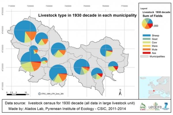
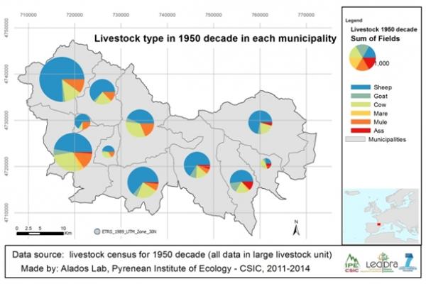
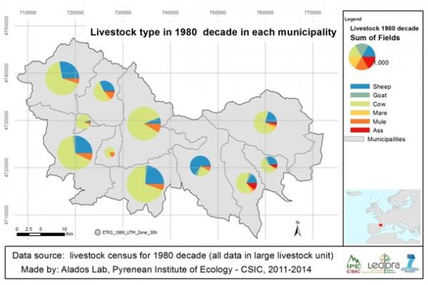
| Assessment | Livestock production is the most important capital in the Central Pyrenees and is highly correlated with population density. During the 1930s and 1950s, the number of sheep far exceeds that of cows. This is largely reversed in the 1980s due to the general abandonment of agriculture and the replacement of charge animals by machinery.
Gini-Hirschman coefficient values shows that agriculture is widely distributed while construction is more concentrated (1981 census data). The Location Quotient confirms the dominance of agriculture (particularly in Torla Yésero and Puertolas), the absence of industry from the whole study area and the reduced presence of services. The construction sector is also relevant in 6 of the 11 municipalities (e.g. Biescas, Panticosa). The diversification coefficient indicates concentrated agricultural activity in most municipalities. |
| Critical functions | - |
| Critical variables | - |
| Social capital | |
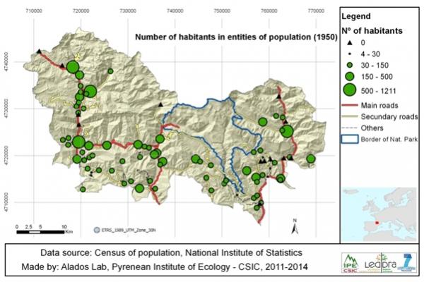
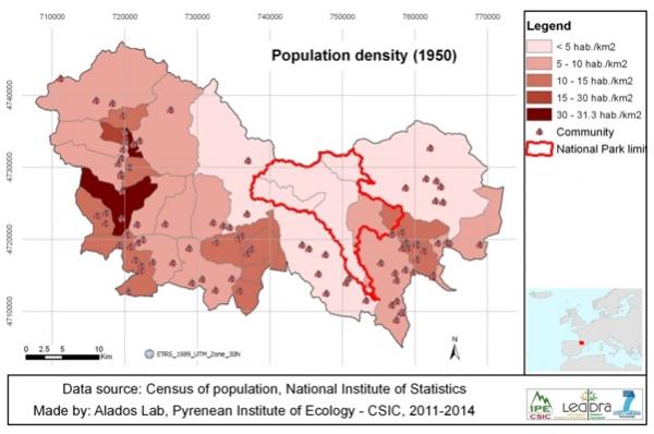
| Assessment | Historically, the population is distributed along the main roads in 86 population centers. The most populous villages are located along the well-connected valleys; particularly the Alto Gállego which is well connected with France and has abundant grassland surface. Population density during the 1950s is very low (from 13.88 inhabitants km-² in Biescas to 3.14 inhabitants km-² in Fanlo). The municipalities with higher densities are located along the Gállego valley, very well connected with France and with industrialized Zaragoza.
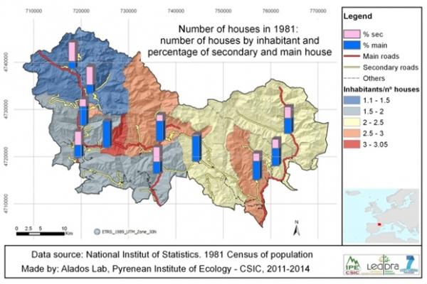
By the 1980s, the density of inhabitant per houses (main and secondary) is higher in the Gállego valley where there are 1-2 individual per house. In the eastern side of the area, there are more than 2 individuals per house. The proportion of second homes is very importanta, particularly in the western and northern areas. |
| Critical functions | - |
| Critical variables | - |
Main LEDD problems and responses
Until the beginning of the 20th Century the local economy is based on natural resources and traditional agriculture with a combination of livestock and winter cereals (wheat and barley), animal fertilization (cultivated/fallow regimes), and the use of alpine and subalpine summer pastures to provide the main source of income. Cultivated lands that occur in the valley bottom and on the lower slopes extend above 1600 m, to include sun-exposed flats called “paneras”. Alpine and subalpine grasslands, the most productive resources of the area, have a short productive period from spring to autumn. Nomadism and transhumance are the main adaptation strategies, allowing an ecological balance between production and exploitation, with livestock moving from the alpine summer pastures to the Ebro Valley. This strategy also reduces the competition for land for growing cereals to feed the human population, rather than growing food for livestock, which suits the self- sufficiency economy. Until 1960, the population is directly dependent on livestock.
After 1941 mechanization and chemical fertilization start in the agricultural sector and a general policy of reforestation is applied. During this period industrial concentration begins, focusing on the chemical industries (Zaragoza, Huesca) and mining (Teruel). Emigration from rural areas accelerates after 1960. Abandoned land tends to be in unfavorable areas, on steep slopes and at high elevations. Former cereal fields are replaced by meadows for livestock grazing or are abandoned. Most of the food required to feed the population is imported. Between 1900 and 1980, the amount of cultivated land decreases from 15% to 5% in Broto Valley, and from 20% to 9% in Biescas-Yésero Valley. Grazing activity becomes sedentary, using supplementary products from agriculture during scarcity periods.


The agro-pastoral economy gradually declines in the 20th century. After 1960, the correlation between number of inhabitants and number of livestock units is negative: the larger the number of livestock the smaller the human population.
Two tourism strategies are developed. One is based on preservation of scenic landscapes, the conservation of wild flora and fauna, and natural heritage. This is particularly developed in Sobrabe county, with the Ordesa and Monte Perdido National Park (OMPNP) as its center. The other strategy involves the development of infrastructure for the skiing industry (between 1965 and 1976), which is used in Alto Gállego County.
Policy context
AK: to check that implementation, impacts and effectiveness of selected policies are discussed in this text. Look at D242 to see if there is any additional information.
--
Properties of the system
AK: to check if there is any further relevant information in D233
Natural capital: --
Economic captial: --
Social capital: --
Socio-ecological resilience
AK: to be added, source: D233
Socio-ecological fit of the dominant response to LEDD
AK: to be added, source: D233