Study sites in cropland
Study sites in grazing land
Study sites in forests
General description of Canyoles River Basin SES
| Authors: | Artemio Cerda, Félix González Peñaloza |
| Editors: | Alexandros Kandelapas, Vassilis Koutsoukos, Jane Brandt |
Editor's note 11Feb13: Source D131-4.3
Location
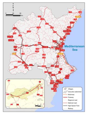
The Canyoles river watershed extends over an area of 62,826 ha in the south of the region of Valencia. Twenty-four municipalities or parts of municipalities are included in the Canyoles rivers basin.
Climate
Canyoles watershed exhibits a dry Mediterranean climate, with dry, hot summers and warm winters. Although rainfall is scarce, extremely high rainfall intensities (daily values exceeding 200 mm) are frequent. Mean annual evapotranspiration exceeds 1000 mm year-¹, resulting in extremely dry conditions for the summer season.
 |
 |
Topography, soils and hydrology
The Canyoles river watershed is characterized by a north and south range that contribute to a long W-E valley flowing form inland Iberian Peninsula to the Mediterranean Sea.
Geography favours the water outlet to the Mediterranean Sea and the genesis of river basins. The Iberian System, to the north of the Canyoles watershed, plays an important role on the water resources cycle in the Júcar river basin.
Parent materials are mainly Limestones, Marls, Keuper clays. Karst type landscapes predominate.
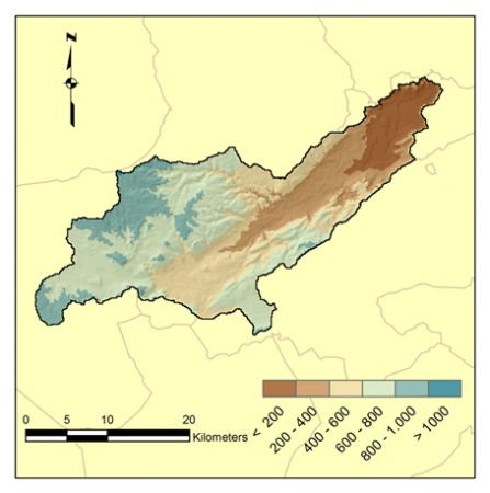
Above 50% of Canyoles watershed has an elevation range between 400–800 m. Areas with altitude classes less than 400m cover about 25% and are located in foodplain. Less than 0.07% are covered with altitudes above 1000m.
The prevalent aspect in Canyoles river basin is Southeast (about 18%) followed by Flat, North, South and Northwest (about 12%).
Canyoles river basin has a mainly landform mainly rolling (about 30%), followed by slopes between 5 and 8% and slopes between 15 and 30%.
Almost, the entire Canyoles watershed has a Calcic cambisol soil type (96.27%), followed by Eutric fluvisol (3.73%). Soils in agricultural land are deep and continuous, with fewer rocks. Carbonated materials and small insertions of detrital material from the Lower Cretaceous, predominate. Jurassic materials appear at the bottom of the valley as alluvial and colluvial depositions. Cenozoic materials are mainly detritical. The study area is geomorphologically represented by a tabular relief of limestones and dolomites, broken by deep depressions, where colluvial and alluvials materials have been deposited in Triassic period.
 |
 |
Canyoles, the main river of Canyoles watershed, exhibits an irregular flow regime with large fluctuations between wet periods and a dry and warm condition. Surface water resources are regulated through large dams.
Ecosystems and land use
 |
Forests and semi natural areas cover less than 60% of Canyoles valley. This group is composed by sclerophyllous vegetation (25.71% of the valley), transitional woodland – shrub (17.25%), complex cultivation patterns (15.45%) and coniferous forest (12.80%). Agricultural areas in the valley cover above 42% its total surface. This group is includes complex cultivation patterns (15.45%), fruit trees and berry plantations (8.32%), vineyards (2.89%) and olive groves (2.27%). Between 1986 and 2006, conversion to agricultural land has been dramatic, facilitated by technical improvements in irrigation systems replacing the traditional flooding irrigation. Changes in landscape have also been dramatic. |
Population and employment
Population in the Canyoles river watershed, is concentrated in the cities of Ontinyent, Xàtiva, Almansa and Canals and is generally increasing. Smaller municipalities and settlements have lost population. Immigration, particularly from Rumania and Bulgaria, contributes to this increase. Labor force has also been rising since 1976, due to the increase in population, agricultural workers’ immigration and women’s entry into the labour market. Canyoles River Basin population is old and aging. Population structure is characterised by low birth rates, partly offset by the arrival of young immigrants.
 |
 |
Employment in the Canyoles Watershed is concentrated in the tertiary (50%) and construction sectors (30%). Agriculture employs less than 5% of the labor force. The employment ratio was improving between 1999 to 2007, but has dropped since. Unemployment is prevalent and intense.
Ownership is the main form of land tenure (86.13%). Utilized Agricultural Area is lower than 5 hectares (per farmer) (88.69%).
Physical and other infrastructure as well as schools are concentrated at the lower part of the valley and the coastal area of the Jucar River Basin.
Particular LEDD issues in Canyoles River Basin
The LEDD issues found at the study area are:
- soil erosion as a consequence of agriculture;
- soil compaction due to herbicide and heavy machinery working on fields;
- soil sealing due to land use changes;
- soil and water pollution due to chemical agriculture;
- reduction of agricultural biodiversity due to herbicides and removal of traditional irrigation systems.
Also, major issues are:
- partial urbanization of the rural areas due to the house and the small agriculture storage building;
- monoculture of citrus plantations in the lower part of the watershed;
- urban growth;
- road and railway growth;
- aquifer depletion, which result in the loss of springs and traditional agriculture;
- industrial development abandonment;
- depletion of farmers knowledge to produce food based on natural and local resources and;
- land abandonment and fires in the nearby mountainous terrain are issues in the study area.