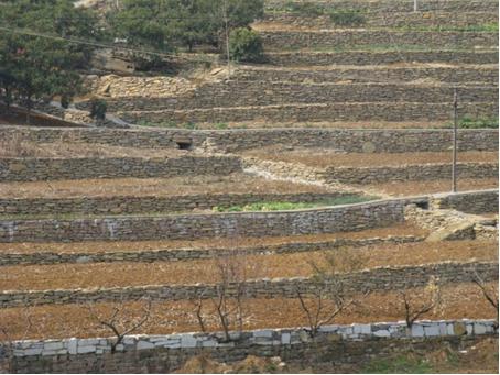
Study sites in cropland
Study sites in grazing land
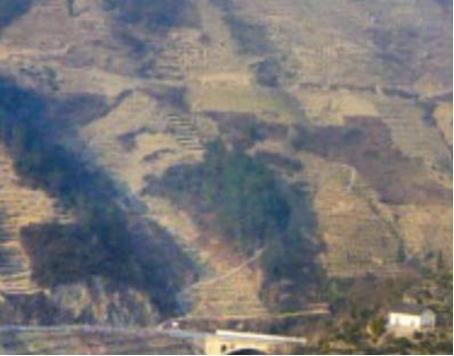
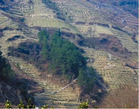
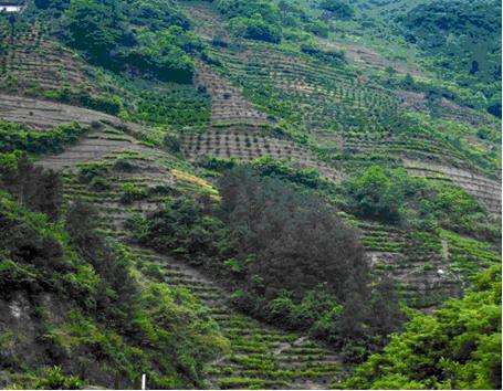
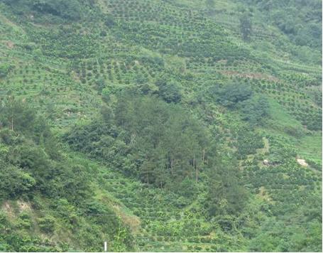
Study sites in forests
Zigui County Socio-Ecological System (SES)
| Authors: | Xiaoping Chen, Bo Hu, Honghu Liu, Feipeng Ren, Zhigang Wang, Pingcang Zhang |
| Editors: | Alexandros Kandelapas, Vassilis Koutsoukos, Jane Brandt |
Editor's note 15Feb13: Source D131-6.2
Location and history
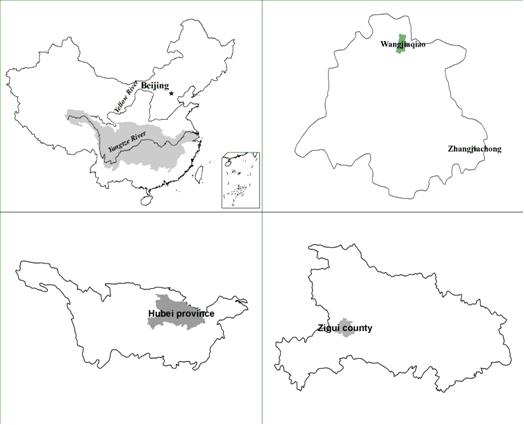 |
Zigui county is located in the west of Hubei province, at the head of Three Gorges and the side banks of Xiling Gorge that is one of three gorges. It covers an area of 2.427 km², with a length of 66.1 km from east to west and 60.6 km from south to north. It includes 186 administrative villages and 6 committees. Because of the reservoir of the Three Gorges Dam Project, part of the Zigui territory has been submerged. Since the establishment of People’s Republic of China, and following the announcement of the land reclamation policy for Zigui County in 1959, 38.5 thousand people have taken part in this action, treating 104 hills and reclaiming 11.1 thousand hectares for agricultural use including 85.3 hectares upland for paddy fields, 42 water conservation projects and the planting of 0.32 million forest trees. Large public investments in terrace construction have also taken place since 1985 (9672 hectares of terraced fields) Farmland construction continues as it greatly improves productivity, but excessive land reclamation does cause soil loss and ecological disturbances. |
Climate
Zigui County has a Subtropical continental monsoon climate with an obvious vertical variation due to rolling mountain landscapes. Rainfall in spring is the lowest, while the highest rainfall occurs during summer period. Yearly precipitation ranges from 950mm to 1590mm with an average of 1439.2 mm. Rainfall increases from north to south or from low elevation to high elevation. Rainstorms are heavier between June and September (40%-60% of yearly rainfall) and in the south-eastern part of the area, with fewer storms occurring along the river. Landforms greatly affect spatial distribution of rainfall intensity.
Continuous drought events are concentrated in the north, middle and west zone, followed by the east zone. Drought between June and September has serious effects on agricultural production. Rainstorms, persistent rainfall or swelling of Yangtze Riveralso cause flood disasters.
Yearly temperature ranges from 6 to 18.3°C. Mean temperatures vary in different areas between 15 and 18°C.Temperature in the county has a yearly variation, with highest values during July and lowest during January. The highest temperatures are recorded along the river. Yearly average evaporation is greater than yearly rainfall, exceeding 1400mm, peaking during the summer months.
Geology
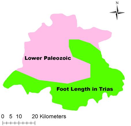 |
Geologically, Zigui County includes a wide variety of layers (geological zones), primarily defined by the Zigui syncline and Huangling anticline stretch which across Zigui County from west to east and the Xianghushan anticline in the south. Southeastern Zigui county (Maoping district) is characterised by the existence of quartz diorite, diorite and plagiogranite. In the east Zigui County (Miaohe and Lanling districts), formations are characterised by marine deposits made up of clastic and carbonate rocks, iron ore deposits and coal seams. In the west, the stratum of marine deposits is made up of dolomite, limestone, glutenite and carbonaceous shale interbedded by coal seaming. Sedimentary deposits in the continental basin consist of conglomerate and glutenite, while the area of the Yangtze and its tributaries is characterised by alluvial terraces. |
More than 20 minerals are found in the province including coal, gold, iron, manganese, copper, lead, zinc, barite, dolomite, marble, quartzite, calcite, feldspar and geothermy. Zigui is one of main coal and gold counties in Hubei province.
Topography
The wider Yichang area is a complex mountainous terrain (24% has altitude 100-500 m, 42% between 500-1000m and 35% over 1000m), dominated by the Three Gorges formations and the winding river canyons.
The Xiling Gorge (encompassing Zigui County) is characterised by south-facing slopes. Prevalent slope value is 15-25° (35% of the area), followed by slopes between 25-35° and 8-15° (22% and 18% respectively).
In the northern and southern part of Zigui County, structural landforms are medium and small formed by endogenic forces including fold, fracture and earthquakes. The central part of the area is influenced mainly by external forces forming karst and valley landforms.
Landslides are frequent and severe. In 1982 (record year), 512 rock falls and landslides, with total capacity of 240 million m³, were recorded. 18 landslides occurred in 2000.
Soils
|
Soils are primarily regosol and fluvo-aquic. Calcareous soils (located in areas with limestone) dominate while purple soils are present in the western part of Xiangxi and Tongzhuang River. Fluvo-aquic soils are mainly found along the Yangtze and Xiangxi River. Paddy soils are found almost in all areas. Soil organic matter content (OMC) is higher in paddy fields than the dry lands. Arable lands generally have OMC of 1-3% (65% of arable land) or less than 1% (25% of arable land). Only 10% of arable land has OMC higher than 3%. Soils are generally sandy and vulnerable to water erosion. Dominant soil texture classes are medium loam and gravelly soil accounting for 37.17% and 39.35% respectively in Zigui County. Other important soil texture classes are light loam and heavy loam (6.14%, and 16.2% of the area respectively). |
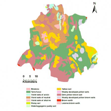 |
Hydrology
Zigui County is located in the wide valley of Xiangxi river and Xiling gorge in the Three Gorges area of Yangtze River. It belongs to the mid-mountain and low mountain zone. The main water-bearing stratum is Palaeozoic and Mesozoic. Ground water belongs to fracture-karst water. Springhead is plenty and has high capacity. Swallet streams, karst caves and underground rivers are plenty. Water is used for drinking and irrigation. Ground water is mostly bicarbonate water.
Ecosystems and land use
The following 7 major ecosystems have been identified in the Zigui County: (a) forest (20% of total area), (b) shrub/grass (13%), (c) urban (7%), (d) agricultural (28%), (e) orange orchard (20% of the total area), (f) bare land (2.5%), and (g) water (10% of the area) (Figure 6.9).
The region has experienced drastic landscape changes during the last 20 years due to the construction of the Three Gorges Dam.
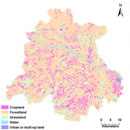 |
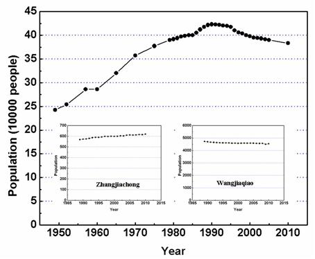 |
Population
Population in the area has increased from approximately 242.000 in 1950 to slightly less than 400.000 in 2010. Population density is around 164 inhabitants per km².
Since 1990, both the natural increase in population and natural growth rate decreased gradually (negative in 2005). However, in 2010 the natural growth rate was 0.50%. The birth rate is around 6% and the death rate around 7%. Both the percentages of younger and older people are decreasing. The childbearing and active labour force are increasing. The elderly dependency ratio has increased reaching 12.9 % in 2010. Education levels are increasing.
Economy
In 2005, the contribution of the primary, secondary and tertiary sectors was 23%, 22% and 55%, respectively.
Average annual economic growth rate was 13.02% between 1979 and 2005 attributed to the quick development of agricultural industries. Since 1992, the county has implemented a "1155" project-based industrial structure readjustment, with the construction of specialised villages producing citrus (249 villages, 48.000 farmers), tobacco (143 villages, 27.000 farmers), tea (75 villages), chestnuts (119 villages), pears (4) and ginkgo (8). Citrus and tobacco provide income of 150 million RMB and agricultural product tax of 10 million RMB.
The economy is centered around agricultural industries with a variety of brands operating in the county encompassing several business ventures and companies, farmers markets, village-level and other business organizations. Citrus production and processing is the leading industry and in 1995 Zigui was named "the hometown of Chinese orange".
Administration
The main administrative functions rest with the County People's Congress, enforcing the Laws enacted by the National People's Congress, promulgating regional management and detailed rules of policies. It is oversees 12 towns which supervise, manage and adjust policies and 186 villages (the lowest policy unit) implementing policies which include water and conservation policies, tillage measures, biological measures, engineering measures, auxiliary measures and other relevant policies.
Infrastructure
The county has 2.165 kilometers of roads and highways, around 600 primary schools, 16 junior high schools and 1431 full-time teachers and 334 medical and health institutions. Preventive health has been introduced since 979 decreasing the rate of infectious diseases from 945.84/100.000 in 1979 to 227.62/100.000 in 2005.
Particular LEDD issues in Zigui county
The main LEDD problems in Zigui (and the Yantze River Basin as a whole) are soil erosion and soil loss, leading to land degradation and desertification. Soil erosion types water erosion, wind erosion, freeze-thaw erosion and debris.
Natural factors and conditions such as steep slopes, broken terrain, mountain collapse, landslides, droughts, floods, and geological disasters, are the main source of erosion. In 1982 alone (a particularly severe year) 2148 square km² (88.5% of the area) was by landslides, rock fall and soil erosion. Soil erosion alone affected 1086 square kilometres (45% of the area) and 19.4 thousand hectares of cultivated land (65% of all cultivated land).
As soils in Yangtze River Basin are generally thin and their textures support high water infiltration rates, high soil nutrient losses are recorded. However, the existence of an impermeable layer under thin purple soil, impedes further infiltration and water returns to the surface, causing a degradation of water quality. Soil infiltration causes nutrient decay especially for particulate nitrogen. Dissolved phosphorus from interflow accounts for a high percentage of phosphorus losses.
Human factors contributing to erosion include lack of water conservation, deforestation, slash and burn cultivation on steep slopes, land use change (mining, roads, urban and industrial expansion) and quarry blasting.
 |
 |
 |
 |
 |
|
Zigui County has also pursued Grain for Green, an ambitious conservation set-aside and reforestation program to prevent soil erosion. Since 2000, Zigui County has restored more than 0.34 million mu of land to forests and grasslands, and its forest coverage reaches 49%.