Study sites in cropland
Study sites in grazing land
Study sites in forests
General description of Wangjiaqiao
| Authors: | Xiaoping Chen, Bo Hu, Honghu Liu, Feipeng Ren, Zhigang Wang, Pingcang Zhang |
| Editors: | Alexandros Kandelapas, Vassilis Koutsoukos, Jane Brandt |
Editor's note 15Feb13: Source D131-6.4
Location
The Wangjiaqiao watershed is located in Zigui County of Hubei Province, China. It is about 50 km NW of the Three-Gorges Dam and covers an area of 1.641 ha encompassing 4 administrative areas: Wangjiaqiao, Chenjiayu, Dashuitian and Qinghaoyu.
Climate
The climate in the Wangjiaqiao small watershed is subtropical.
Annual rainfall varies among years from less than 1000 mm to 1500 mm. Average annual precipitation is 1016 mm, 70% of which occurs between May and September. The annual average temperature is 18°C, with an average summer maximums in July (28°C) and average winter minimums in January (8°C). Mean temperature varies between 11 °C and 18°C. Average annual evapotranspiration is 811 mm, ranging from around 680 mm to 1250 mm.
Topography, soils and hydrology
 |
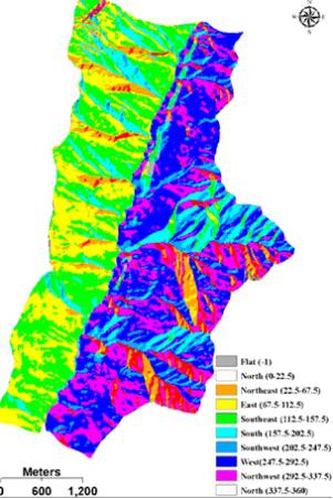 |
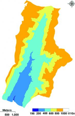
Parent materials of this area are mostly Cretaceous or Tertiary purple shale, sandy shale and sandstone, containing large quantities of iron and manganese oxides. The terrain of the watershed is mainly hilly, with a lowest elevation of 195 m and the highest elevation of 1110 m ASL. Slope gradient ranges from 2° to 58° with an average of 23°. The area’s altitude is between 400-1000m (86%). The most common aspect is west, covering (23%), followed by south-east (15%) and Two main soil great groups occur in the Wangjiaqiao small watershed, namely, purple soil derived from purple sandy shale, and paddy soil developed from the purple soil. |
The prevailing soil depth class is 30-50 cm (60%) followed by the 15-30cm class (25%) and 50-70 cm class (15%).
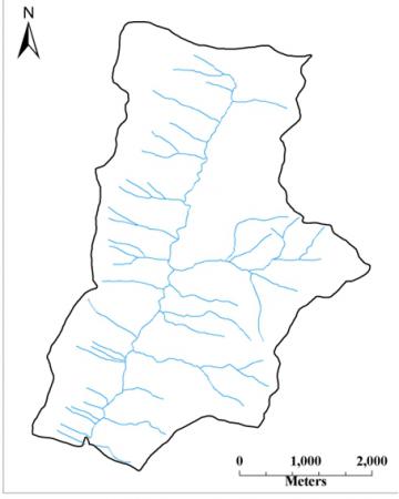
Streams in the Wangjiaqiao watershed have a pinnate drainage pattern, and the length of the main channel is about 6.500 m. Surface water runoff is greater in the summer (114 mm), and lower in spring (49 mm), autumn (46 mm) and winter (10 mm). Most sediment yield is contributed in the summer with a total load of 6527 t, followed by spring and autumn with loads of 1104 and 334 t, respectively. Total runoff generated by rainfall varies between 0.22 and 84.88 mm, with a mean value of 16.45 mm. Peak discharge oscillates between 0.16 and 87.9 m³/s-¹. Base flow level fluctuates from 0.01 to 0.58 m³/s-¹.
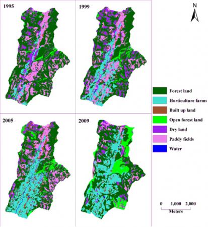
Wangjiaqiao watershed is a terrestrial ecosystem. Dominant land cover types are forest land (55%), horticulture farms (30%), paddy fields (6%) and upland (6%) and built-up land (3%).
Population, employment and income
Population in 2010 is approximately 4500 people (down from 4725 in 1989), with a slight male majority.
During the same period, annual birth rate has consistently exceeded the death rate.
Total dependency ratio has a decreasing trend, which can be explained by the decline of young dependency ratio and by the nearly constant old dependency ratio. There are more imigrants coming than there are emigrants leaving.
Agriculture is the main source of employment (33%) complemented by employment in public works in the area.
Both gross income and total expenditure has an increasing trend, but increase of gross income is higher than total expenditure. In 2010, gross income was 1923 0000 RMB and total expenditure for agricultural production was 694 0000 RMB.
All farmer issues in the area are managed by the village offices.
Land use
Land use has changed in the past 15 years in two main ways:
- During 1995-1999, the area of forest and paddy field decreased, while all other uses increased, particularly horticulture farms.
- During 2005-2009, the area of forest horticulture farms and particularly open forest increased.
Built up areas covering 3% of the total land area, while the length of roads is 16 km, located mainly at the low elevation region.
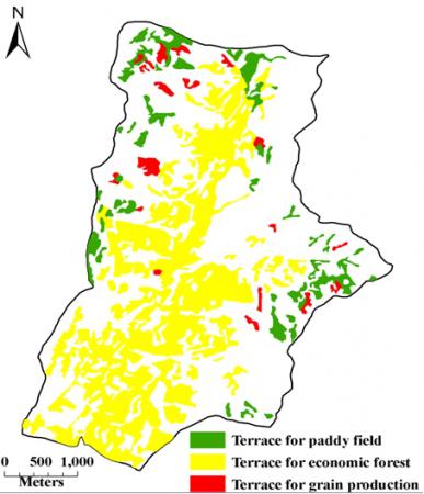
Terraces have been built in an area of 617.72 ha, corresponding to 92.56 ha for paddy field, 497.39 ha for economic forest and 27.77 ha for grain production. The drainage network is used to drainage the rain water runoff.
 |
 |
 |
 |
Particular LEDD issues in Wangjiaqiao
In 1989, the Wangjiaqiao watershed became a key experiment watershed of the National Watershed Treatment project, employing a comprehensive approach to address soil erosion, develop the rural economy and improve the natural environment. At the time, soil erosion in Wangjiaqiao affected 1241 ha (74.% of area), and the soil erosion modulus was more than 50t/(hm²*year). Treatment measures include five elements:
- Closing hilltops to facilitate afforestation, taking full advantage of the restoration function of natural ecological systems. To achieve this goal, villagers took a series of measures, such as developing rules, scoping areas, personal treatment, assigning responsibilities, reducing runoff, increasing organic matter. Until 1995, the area of closing hilltops was 200 hm².
- Artificial planting robinia and cypress on waste hillsides and around houses and settlements. These species exhibit fast growth, high canopy density, fine crown and well developed roots.
- Developing productive plantations on sloping farmland of 25° to 35°, by converting cropland. Citrus was panted below 600 meters of elevation, and chestnut, tea and eucommia above 600 meters.
- Constructing level terrace on sloping farmland of 15° to 25°, to address the most important soil erosion factor. The villages modified the sloping farmland to stone bunded level terraces or hardened soil-bunded level terraces. The main rules were planning globally along the mountain ridge. After seven years, increased level terrace area was 364 hm² and productivity increase exceeded 1200kg/hm², while reducing runoff and soil erosion.
- Constructing engineering structures based on soil erosion classes/types, including drains and reservoirs (to serve the level terraces), diversion canals and weirs (for drainage and irrigation) and a number of check dams and sand-sediment dams at gully regions.
By closing a large area of hilltops to facilitate afforestation, planting economic forest robinia and cypress and constructing level terrace, the forest area of Wangjiaqiao watershed increased from 28.3% to 56.8%. Other infrastructure serve to protect soil and water resources and increase land productivity.