Study sites in cropland
Study sites in grazing land
Study sites in forests
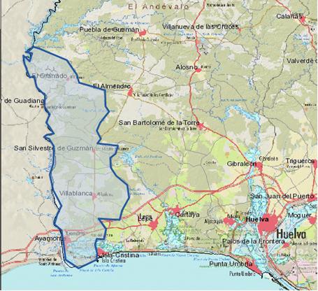
General description of Western Andévalo SES
| Authors: | Michiel Curfs, Anton Imeson |
| Editors: | Alexandros Kandelapas, Vassilis Koutsoukos, Jane Brandt |
Editor's note 1Mar13. Source D131-5.3.
Location
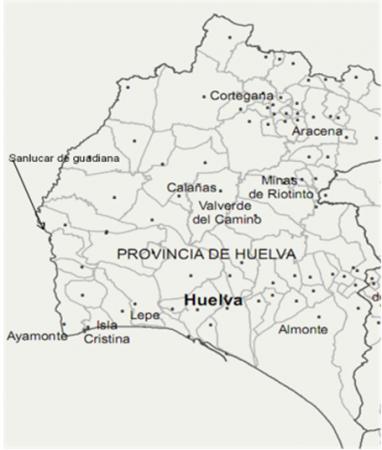
The Western Andévalo study area covers an area of 47.500 hectares in the south-western part of the Huelva province, Andalusía, Spain. The area includes 5 municipalities with approximately 25.000 inhabitants. The biggest municipality both in size and population is Ayamonte. Ayamonte is the coastal town situated at the estuary of the river Guadiana. The study area borders with Portugal on the west and with the province of Seville to the East. To the north lies the Extremadura, and to the south is the Gulf of Cadiz along the the Atlantic coast.
 |
 |
Climate
The climate is typical Mediterranean with hot and dry summers and wet periods in the winter. Almost all precipitation (avg. 500 mm/year) falls between November and March. Rainfall records show a declining trend in the total amount. Although the average deviation in annual rainfall is about 500 mm/year, the records show extremes. Evapotranspiration is estimated at approximately 900 mm/year. With an average rainfall of around 500 mm/year this leads to an aridity index of 0.55.
Geology, topography, soils and hydrology
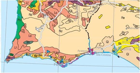
Geologically, the largest part of the study area is of carboniferous origin, consisting of shale, slates and greywacke of fluvial origin. A smaller part in the municipality Sanlϊcar de Guadiana is also carboniferous material, but of volcanic origin namely, Tuff, lavas, acid breccias and quartz. The south of the study area, near the coast, presents younger formations deriving from the Quaternary, consisting of conglomerates, gravel and red clay.
The elevation level of the western Andévalo does not exceed 200 m A.S.L., dominated by low to medium level undulating to rolling landscapes, on metamorphic material.
Soils are Leptosol, (Eutric) Regosol and (Eutric) Cambisol, generally shallow and low in nutrients and organic matter. The parent material is mainly flysh (north), shale (central) and conglomerates (south-coast).
 |
 |
Soil depth ranges from no soil to 100 cm. Soils on undulating slopes are shallow or absent. The only thick and developed soils in the region can be found in the flood plain terraces of the Guadiana river. Rock fragment presence in agricultural soils is high (more than 60%).
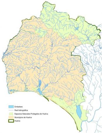
The natural drainage system is characterised by human intervention and modifications of water flow. The complex dendritic river network consists of well-incised gullies with seasonal torrential regimes with high erosive capacity. The dams in the area are the Andévalo, the Chanηa, the Odeleite and further up north on the Guadiana is the Alqueva, the biggest reservoir of western Europe.
Ecosystems and land use
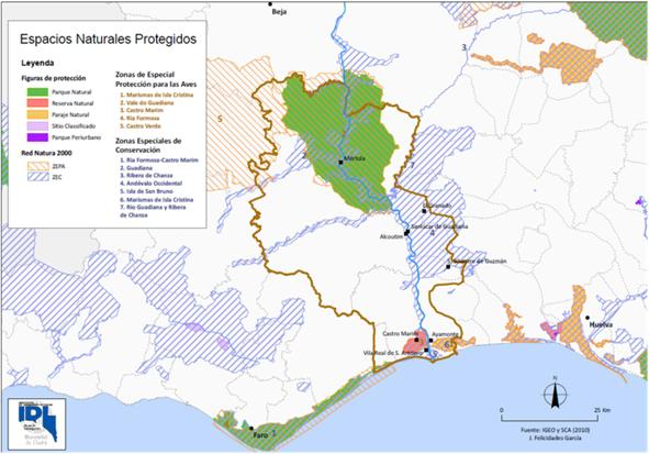
Ecosystems in the area include Forest, Sub-humid semi-arid dryland, Cultivated and Urban. With regard to biodiversity, Western Andévalo includes several protected areas, national parks and natural reserves, while the estuary of the Guadiana is also a RAMSAR site.
 |
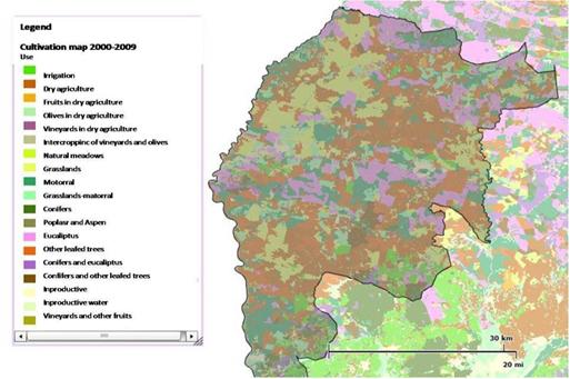 |
Agricultural land use in Western Andévalo includes a variety of types of cultivation. Until 1982, a trend of farm consolidation was evident, followed by a dramatic reduction (approx. 10,000 hectares) in cultivated land between 1982 and 1989.
Population, employment and income
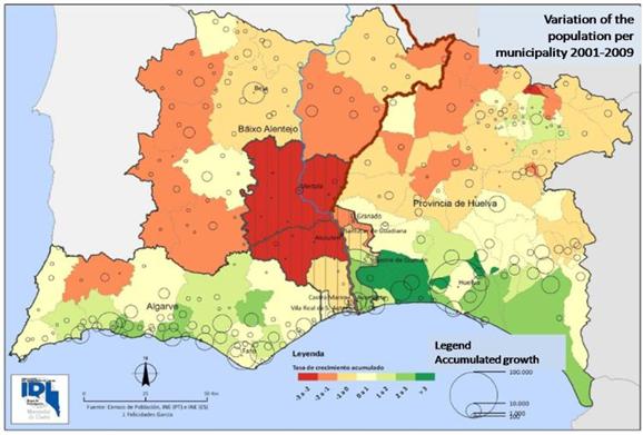 |
Population is declining in the interior and rural areas and increasing in urban areas and the coastal zone. Overall, population density has increased since 1996, due to high densities along the coast. Population ageing is a serious issue in the study area. From an almost perfect population pyramid in 1910. ageing indices for all communities in the study area are now in the range of 100% up to 300%. Population increases since 1990 are directly linked to migration. Registered immigrants are mostly Europeans followed by Africans and South Americans. Huelva is the province with most temporal workers in agriculture in Spain, although these workers are not necessarily residents of the area. |
Nevertheless, the service sector is the dominant sector of employment in Huelva province (more than 50%). This trend is evident in all municipalities apart from San Silvestre de Guzman, where agricultural predominates.
Annual average income per capita for Huelva in 2003 was €8.130.
At over 30%, unemployment is particularly severe in Huelva and generally higher than the Spanish national average Unemployment of the under 25s exceeds 50%.
Infrastructure
Several NGOs are active in the area.
Although, road network density is low, the tarmac roads are in excellent condition, with low traffic. Very few schools exist in the rural inland part of the study area. For further education students may need to travel as far as 25 km. No higher education institutions operate.Basic medical needs are covered by village medical centres but for more serious issues and emergencies patients have to travel further to the nearest hospital.
Particular LEDD issues in Western Andévalo
The main LEDD problems of the semi-arid area of Western Andévalo are related to water and soil (organic matter).
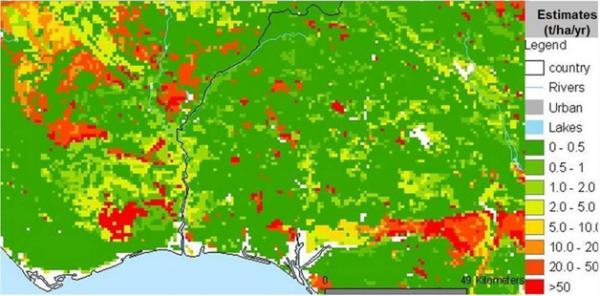
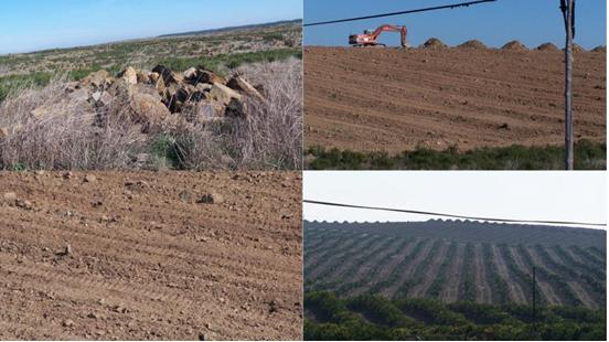
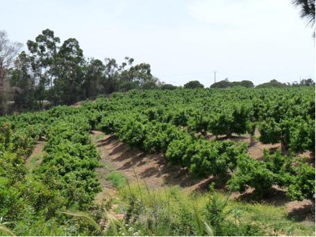
Soil erosion varies within the area, from 0-0.5 t/ha/yr to more than 50 t/ha/y. Orange plantations are particularly susceptible to erosive processes, as trees stand on bare soil on undulating slopes, with very little or no undergrowth. Evidence of rill erosion, such as gullies between planted mounts, are common, particularly at older plantations. New, rapidly expanding citrus orchards tend to ignore natural patterns of relief in the landscape and have very high degrees of soil erodibility. Typical land conversion to this type of citrus orchard includes parallel mount-depression-mount patterns, compaction by heavy machinery, complete vegetation removal and long periods in which the area is left bare before planting starts. This processes is increasing due to ongoing support and financing from regional and EU authorities of supported for the Garcνa-Carriσn processing plant in Western Andévalo, with a capacity of processing 200 million kilos of oranges per year and packing 120 million litres of fresh orange juice. To reach its maximum capacity the plant needs the raw materials from 8,000 ha of citrus groves and is presently supporting the conversion of a further 3,450 hectares of land into orange groves.
 |
 |
Major land uses changes are also brought about by urban expansion due to housing construction, concentrated in the coast and the town of Ayamonte. The 'Costa Esuri' development alone includes 6000 apartments over an area of 950 ha. In Andalucia, tourism is the largest consumer of the urban water resources, with a consumption rate that reaches its peak in the summer months, which coincides with the peak agricultural demand for water.
Water demand for irrigation has increased dramatically in recent decades, absorbing 80% of available water resources. Agricultural water is primarily supplied by superficial resources, such as small reservoirs. Coastal crops are irrigated with ground water, which causes serious damage to aquifers because of marine intrusion due to overexploitation.
In response to declining mining activities and growth of the primary sector, the Junta de Andalucia is also implementing the 60 million Euro plan "Regadío del Andévalo" (irrigation of Andévalo), combining a network of waterways to deliver water from the Andévalo dam to areas needing irrigation (target of 6500 m³ of water per hectare per year). These areas will then be converted to plantations for the cultivation of citrus fruits, nuts and olives. The areas for cultivation will be divided over 17 municipalities in the region. While the newly irrigated areas are expected to create approximately 400,000 jobs with a total production of 100 million Euro, the scale of the project points to further erosion problems.
Huelva province has the highest concentration of strawberry production in the world, contributing to Spain's position as the biggest European producer and 2nd biggest global producer. Nevertheless, strawberry production is directly related to aquifer overexploitation and depletion.
The expanding water-consuming agricultural practices of Western Andévalo also affect international relations as the Guadiana river basin is international and shared with Portugal, with the river serving as the border between the two countries.
The study area is also affected by pollution related to acid drainage from sulphide ore mines in the Iberian Pyrite Belt, the northern part of the Huelva province, as well as phosphogypsum runoff from of phosphate fertilizer production sites in the city of Huelva.
Land abandonment following rural migration as young people moves away, seeking employment in the coast and cities, may contribute to accumulation of soil organic matter and biodiversity conservation, but also dramatically increases fire risk.
Irregular rainfall patterns induce water stress, predicted to worsen according to changing climate scenarios for the Iberian Peninsula. Expected climatic changes for the area include smaller amounts of rainfall in more intense bursts, expected to exacerbate erosion.
 |
Emerging responses to LEDD, particularly with regard to citrus orchards, include
|
Positive responses also include international afforestation projects on both sides of the lower Guadiana basin, part of wider efforts at collaborative water management and overall cross-border cooperation.