Study sites in cropland
Study sites in grazing land
Study sites in forests
General description of Gorgoglione
Editor's note8Mar13: Source D331-2.4
| Authors: | Agostino Ferrara & Giovanni Quaranta |
| Contributing Authors: | Sofia Bajocco, Antonella De Angelis, Giuseppe Mancino, Alberto Mancini, Francesco Ripullone, Luca Salvati, Rosanna Salvia |
| Editors: | Alexandros Kandelapas, Vassilis Koutsoukos, Jane Brandt |
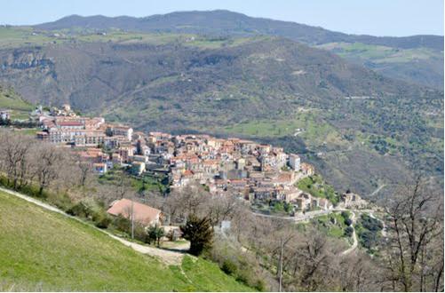 |
Location The local community of the municipality of Gorgoglione is in many ways a typical Apennine, Southern Italian community. It is located in the central-eastern part of Basilicata, between the valleys of the Sauro stream and Fiumara of Gorgoglione torrent and covers 32 km² (0.01% of the region), at an altitude of 800 m above sea level. |
Climate
Climate is Mediterranean, with average yearly rainfall between 789 and 893 mm, concentrated in the autumn-winter season. From a phytoclimatic point of view, the area falls between the submontane horizon Lauretum cold and Castanetum warm or vegetation belt Quercus-Tilia-Acer.
Geology, topography, soils and hydrology
The lithostratigraphic unit is the "Gorgoglione Formation", a Miocene formation with grey clay schists and grey quartz-feldspathic sandstone, with a layer of white limestone marl with flint nodules its base. The prevailing granulometric component is salty clay which combined with digenetic processes confers a high degree of compactness to the rocks.
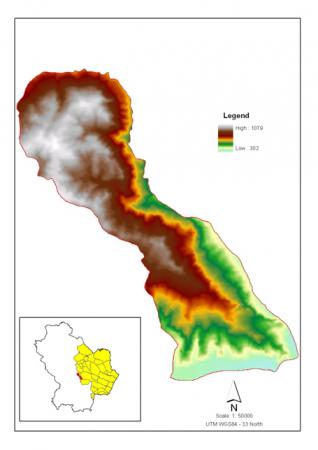
Minimum altitude is 322 and maximum of 1080 m a.s.l.
High presence of clay renders the land easily subject to erosion and landslides. The forest area soil is on land with Litho sol and Camisole substrates, characterized by high depth, a strong skeletal presence, with average or coarse granulometric and a basic or neutral reaction. Land dedicated to sowing and/or pasture is found on areas characterized by cracks and fissures, close to a substrate of shale's and siltstones, deep Camisoles and Retools.
The Municipality is located in the sub-basin of the Sauro stream, a tributary of the Agri river. Streams in the sub-basin cause significant erosions and landslides, due to the low lithological consistency of the area (mostly clay ground). Transport of solid material by the current prevails over sedimentation. Ground water is contained in soils that are permeable due to porosity (floods). Small aquatic layers are present throughout the territory.
Ecosystems and land use
Land is generally privately owned.
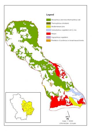
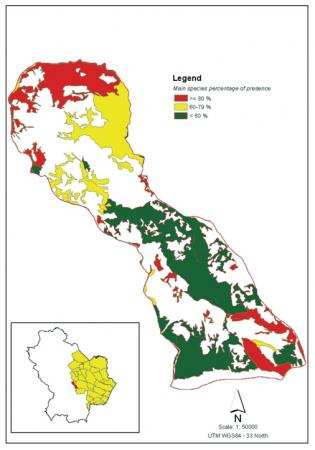
The overall forested area of Gorgoglione Municipality is 1672 ha (48.% of the territory). Vegetation consists of deciduous oaks ranging from 400 m to the mountain tops. Types of forests include the three main species present in the area (Quercus cerris L., Quercus frainetto Ten., Quercus pubescens Willd). Woodland is 79% tall forests, 0.6% coppice, 20% low and tall bushes and 4.6% coniferous plantations. Forests and non-irrigated agricultural land (for cereal production) account for 80% of Gorgoglione territory. Pastures are limited to 40 ha.
 |
 |
 |
Gorgoglione forests have survived significant pressures in the last two centuries (population growth and conversion to agriculture in the 19th century, increased felling during World War II, railway construction). Although forestry had been in decline until the 1990s there has recently been a revival. Abandonment of agricultural land since the 1980s had led to general afforestation gradually coming under silvicultural management by private owners (160 ha). Despite the existence of 10-year Forest Management Plan, State forests (522 ha) suffer from lack of management resulting in high density which combined with a series of dry periods triggered mechanisms of extreme competition between the tree species: about 30-40% of state forest is decaying or completely dead. Annual wood increment is about 2 m³ per hectare.
Population and employment
Population is 1,063 and population density is 32 inhabitants/km² (average regional density: 60). Gorgoglione and the rest of the hilly areas of the "Collina Materana" have experienced a sharp population decline in the last century.
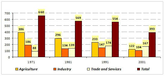 |
The 2001 census shows only 63% of economically active population employed, with 37% unemployed and 33% employed in agriculture. A major economic activity of Gorgoglione municipality is stone extraction, processing and crafts centred around the local sandstone, "Pietra di Gorgoglione". A dozen companies and approximately one hundred workers are employed in the sector. |
|
Administration and infrastructure The municipality is governed by the Council of the City (policy and political control), the Board (administration) and the Mayor. Gorgogiolone is covered by the local road network and hosts a local healthcare and first aid station, a nursery, a primary school and a low secondary school, a library and an office of tourism. Policies in effect The main local instrument regulating forests and pasture areas in Gorgoglione is the Forest Management Plan. The Plan includes provisions for the exercising of community rights: all citizens with permanent residence in the territory have rights to pasture, harvesting trees and arable land, upon payment of a fee and commensurate with family needs. |
 |
Particular LEDD issues in Gorgoglione community and responses made
The main LEDD problems in Gorgoglione Community are:
- Forest productivity decline, primarily due to abiotic factors such as the increase the frequency of extreme climatic events frequency (drought, late-spring frost, floods). Other causes are the mismanagement of forest resources and uncontrolled grazing in forest.
- Soil erosion and surface landslides caused primarily by the nature of the geological substrate (clay, flysch). It is exacerbated by poor agricultural practices and overgrazing.
- Water stress and deterioration of forest cover affecting mesophylous and meso-termophylous oak and coniferous reforestation. Poor seasonal climatic conditions, poor soil quality and in some cases overgrazing, create a high sensibility to water stress.
As in the Matera Study Site, responses to LEDD problems in Gorgoglione include the Regional forestry laws, the Triennial Forestation Plan, the Triennial Fire Protection Plan and the Forest Management Plan, to reduce the effects of forest productivity decline, soil erosion and water stress and deterioration of forest cover.