Study sites in cropland
Study sites in grazing land
Study sites in forests
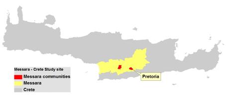
General description of Protoria
| Authors: | Constantinos Kosmas, Mina Karamesouti, Thanasis Kizos, Katerina Kounalaki, Minas Metaxakis |
| Editors: | Alexandros Kandelapas, Vassilis Koutsoukos, Jane Brandt |
Editor's note 29Nov12: Source D131-2.4
 |
Protoria is located in the lowland of the south-eastern part of the Messara valley. The area is subject to occasional flooding by the local stream and is protected by the Platanias dam. The total area of the study community is 779.5 ha. Annual rainfall is estimated at between 750 and 1000 mm while annual air temperature ranges is in the 15-18°C class.
|
Economy
The economy of the community is mainly based on agriculture, as the area is intensively cultivated with olives, and to a lesser extent vines and vegetables. There are strong economic interrelations with the nearby villages of Asimi, Gortyna, Arkalochori and Pirgos.
Main LEDD problem
The main LEDD problem in the area is ground water pollution due to agriculture and soil erosion in the southern part of the community.
Topography and soils
The community is at an altitude of 200-400m and generally characterized as level land with a slope gradient less than 2% in 84.9% of the community area. The area has a primarily south-facing aspect (46.4%) and to a lesser extent east-facing aspect (31.0%).
Due to its location in the valley bottom, the area receives fluvial materials transported by the local water streams forming an almost flat plain: 65,4% of surface geological material of the area is alluvial. The prevalent soil category is Fluvisols (83.6%), favoured by frequent flooding in recent decades. The next important soil type is Cambisol (15.1%) located around the Protoria village, exhibiting moderate soil development with the formation of the representative soil horizon cambic.
{tip 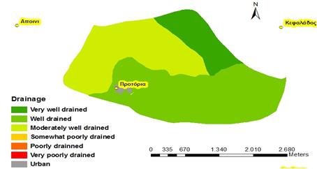 Spatial distribution of soil drainage classes in the Protoria community. Source: LEDDRA project} {/tip} |
Soil textural class is predominantly moderately fine (87.4%) and characterized by low to moderate soil hydraulic conductivity, moderate to high water holding capacity, and moderate risk to ground water pollution by chemicals. Remaining soils (11.8%) are of coarse texture and characterized by high variation of soil texture with depth. 84.9% of area soils are characterized as very deep (>150 cm) and 10.9% as deep (100-150 cm). Soils in the community are generally very well to well drained (50% of the area). Moderately well drained soils cover 35.5% of the area. |
|
Ecosystem The whole area is characterized as a cultivated ecosystem: 85.8% of the area is covered by olive groves, 13.8% by vineyards and 0.3% by complex cultivation patterns. Natural areas are almost absent except riverbanks. Urban areas cover 0.8% of the community area. The remaining lands are grazing lands.
|
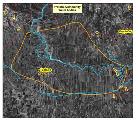
Hydrology Water bodies in the Protoria comprise of two water channels, both tributaries of Anapodaris River. The main water sources for irrigation are groundwater and the Plakiotissa reservoir (18,600,000 m³ capactity). |
|
 |
Population and infrastructure
Protoria is a small community of 369 inhabitants and one of the 72 settlements of the Messara area. It is part of the Archanes-Asteroussia Municipality. While the population of Protoria doubled from 1971 to 1991, it has decreased by 11% since 1991. Population ageing is also evident in Protoria and at a greater degree than the Prefecture or the region. Protoria is not located on the major transport axes of the former Prefecture, but at the same time it cannot be considered as isolated either. For schools and childcare services, Protoria is serviced by nearby Harakas and Pyrgos. For healthcare, residents typically travel to Heraklion. The majority of residents of Protoria are graduates of primary education while 11.4% have not finished primary school and 9.7% are illiterate.
Agriculture
The primary sector (farming) remains the main source of employment although employment in services has increased in recent decades.
|
|
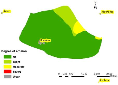
The Agricultural Cooperative of Pretoria is the main farmer organization dealing in olive oil and table grapes. It is a member of the Union of the Agricultural Cooperatives of Heraklion (AGRUNION) and also a member of the union of Agricultural Cooperatives of Messara (EAS Messara). As the land is almost flat, soil erosion is not a direct threat. However, agricultural practices, such as vegetation clearing for collecting olive fruits, do have adverse effects both on soil water: amounts of water stored into the soil are declining and soils exhibit high surface crusting and lower organic matter in soil surface.These processes also have socio-economic impacts: higher olive oil cost production and higher labour and energy consumption. |
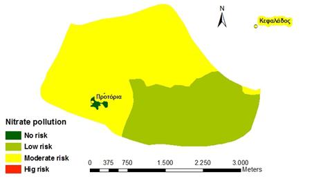
Pollution
|
The land is intensively cultivated by applying fertilizers, pesticides and herbicides, and water for irrigation. Under such conditions, the existing aquifer is subjected to chemical deterioration due to leaching of the applied chemicals such as nitrates. The Protoria community area is characterized mainly by moderate potential risk for nitrate pollution of ground water. Areas of moderate risk to nitrate pollution are estimated in 61.6% of the total study area. The rest of the area (37.6%) is characterized as subjected to low risk to nitrate. Chemical deterioration of water resources in the Protoria community does have negative environmental and social impacts including reduction in water availability for human consumption and eutrophication of surface waters. |
 |