Study sites in cropland
Study sites in grazing land
Study sites in forests
General description of Gagales
| Authors: | Constantinos Kosmas, Mina Karamesouti, Thanasis Kizos, Katerina Kounalaki, Minas Metaxakis |
| Editors: | Alexandros Kandelapas, Vassilis Koutsoukos, Jane Brandt |
Editor's note 29Nov12: Source D131-2.5
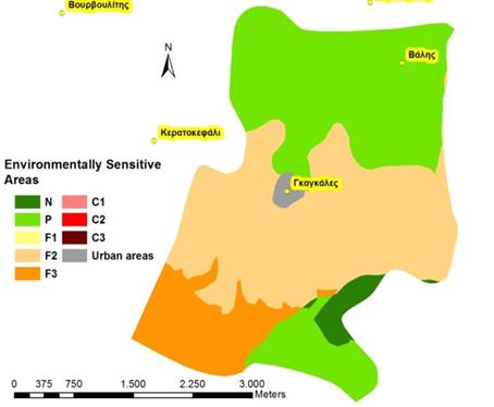
Location
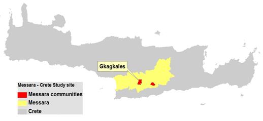 |
Gagales community is located in the north-central part of the Messara valley covering an area of 1.224 hectares. Annual rainfall is between 500-750 mm in the lower part of the community and 750-1000 mm in the upper part. Annual air temperature ranges between 15-18°C in the upper part and 18-21 °C in the lower part. |
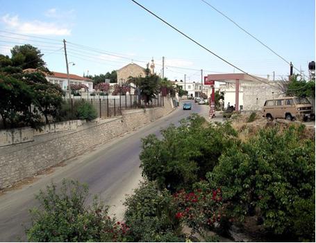 |
The local economy is mainly based on agriculture, as the area is intensively cultivated with olives, vines and vegetables. The community has strong economic interrelations with the nearby villages of Gortys, and Tympaki. The main LEDD problem of the area is soil erosion and land desertification exacerbated by the community’s hillside location. |
 |
|
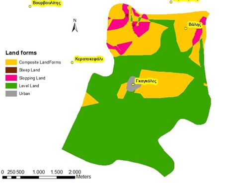
Topography The area’s altitude class is 200-400 m, with flat areas covering 32.9%, south-facing slopes 56.7% and north-facing slopes 10.4% of the total area. Slope gradients are predominantly less than 8% although moderate slopes covering an 34% of the area. Sloping land with dominant slopes between 8% and 30% is mainly located in the northern part of the community, covering 4.8% of the total area |
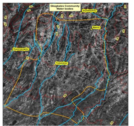
Hydrology Water bodies of Gagales community include four water channels, all tributaries of Geropotamos River. They are ephemeral channels carrying water during winter and early spring. The main source of irrigation water is the Messara Valley groundwater. |
|
 |
 |
|
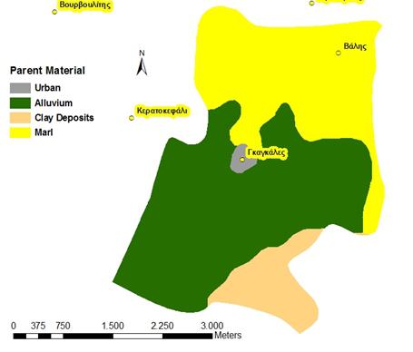
Geology and soils Surface geological materials are mainly alluvial (52.9%) and marl (36.2%) deposits. The latter are located in the upper hilly areas. In the southern part of the area, clay deposits form the uppermost geological formation, covering 9.9% of the total area. The whole area’s soils fall under the Cambisols category. Soil textural class is moderately fine, characterized by low to moderate soil hydraulic conductivity, moderate to high water holding capacity, and moderate risk to ground water pollution by chemicals. Soils tend to be moderately deep (42.4%), deep (46.7%) and very deep (9.9%), containing amounts of rock fragment of up to 40% in the soil surface. Soils are well drained. |
 |
Ecosystem
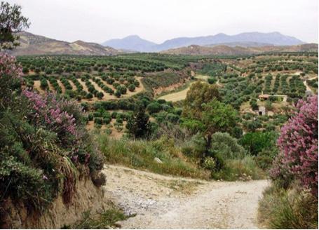
The whole area is characterized as a cultivated ecosystem, dominated by olive groves (92.1%) and vineyards (5.9%). Natural areas are almost absent except riverbanks.
Population and infrastructure
Gagales is one of 72 settlements of the Messara area and forms part of the Municipality of Gortyna. It is a community of 605 people, remaining relatively stable during the last 50 years. Population ageing rates are higher for Gagales, than for the rest of Heraklion and the values of dependency indicators point to dramatic ageing and increases in the non-active populations.
The physical infrastructure in the settlement is part of the overall infrastructures of the Municipaitly and the Messara area in general. One kindergarten and one primary school operate in Gagales. For secondary education students travel to Agioi Deka. For healthcare, residents of the settlements typically go to Heraklion.
Employment
 |
 |
The primary sector (farming) remains the main source of employment (71%) although the contribution of the tertiary sector has increased in recent decades. Unemployment has increased 5-fold since 1991. Half of the population are primary education graduates while 15.9% have not finished primary school and 2% are illiterate. Only 4% are university graduates, but significantly higher than previous decades. |
Agriculture
 |
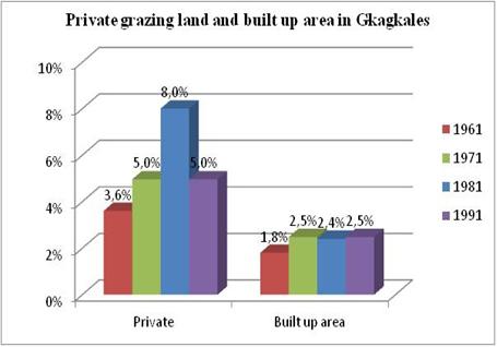 |
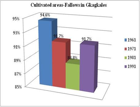
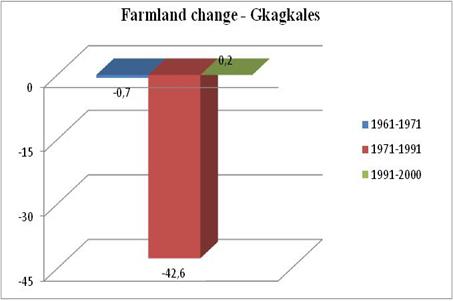
92% of the area is covered by olive groves which have in the last three decades replaced all arable cultivations. The percentage of private grazing lands ranges between 5 and 8% and built up areas have increased from 1.5% in 1961 to 2.5% in 1991. |
 |
 |
Land degradation and desertification
|
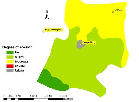
Soil erosion poses a significant threat for Gagales and in particular those sloping areas intensively cultivated with olives. The most important erosion driver is conservation of soil water and clearing the land for collecting olive fruits, whereby farmers leave the land partially bare of vegetation. In addition, due to the presence of marls soils exhibit low hydraulic conductivity and generate high surface water runoff during the wet period. Slightly eroded soils cover 56.6% of the area, primarily in its lower part, while moderately eroded soils cover 36.2% of the area. Biophysically erosion results in lower amounts of water stored into the soil, high soil surface crusting and lower organic matter in the soil surface. Its socio-economic impacts include higher olive oil cost production, higher labour and energy consumption. Because, the land is intensively cultivated in the Protoria community by applying fertilizers, pesticides and herbicides, and water for irrigation. Under such conditions, the existing aquifer of Messara Valley is subjected to chemical deterioration due to leaching of the applied chemicals such as nitrates. In addition, surface water runoff can remove fertilizers enriching surface waters. The whole area is characterized as subjected to moderate risk to nitrate pollution of waters. The main impacts of chemical deterioration of water resources in the community can have negative environmental and social impacts such as: reduction in water availability for human consumption,eutrophication of surface waters, reduction of tourists arriving in the area and production of low quality of agricultural products. |
 |
 |