Study sites in cropland
Study sites in grazing land
Study sites in forests
General description of Central Pyrenees SES
| Authors: | Alados Inma, Erea Paz, Fillat Frederico, Gartzia Maite |
| Editors: | Alexandros Kandelapas, Vassilis Koutsoukos, Jane Brandt |
Editor's note 5Mar13. Source D231-2.3.
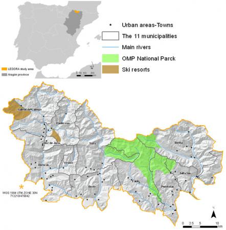 |
Location The Central Pyrenees study area is located in the Pyrenees mountain ranges, in the north-east of Spain, bordering France. It includes 11 municipalities, 6 of them in Sobrarbe region (Torla, Broto, Fanlo, Puertolas, Tella-Sin and Bielsa), in Ordesa and Monte Perdido National Park and surrounding peripheral zone of protection. Of the remaining 5, 3 (Sallent de Gallego, Panticosa and Hoz de Jaca) are directly affected by ski resorts and the other 2 (Biescas and Yesero) by the ski business. Out of total of 90 villages in the study area, 27 villages have no permanent inhabitants or are abandoned. |
Climate
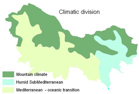
The complex topography and the diversity of aspects of the mountains offer an extensive variation of local climatic shades. Nevertheless, based on the pluviometric distribution and on the more or less continental character, we can differentiate in the Central Pyrenean study area three zones; mountain, humid sub-mediterranean and mediterranean (oceanic transition) climates.
 |
 |
Precipitation and temperature are directly correlated with the altitudinal gradient. Higher elevations have higher precipitation and lower temperatures than lower areas. Further, the eastern part presents more continental characteristics with lower precipitation and higher contrast in temperatures. Annual precipitation in the Central Pyrenees varies between 1,307 mm at the bottom of the valley and 1,718 mm in the mountain, with significant snowfall even in lower elevations and more than 100 days with frost. The rainiest months are October and November in the western part of the study area and May in the eastern part. Minimum annual average temperatures are between -1°C at higher elevations and 6ºC at the bottom of the valley. Maximum annual average temperatures are between 3.5 and 19 °C. The coldest months are January and February and the warmest July and August. ET0 is lower at the high levels, and highest at the valley bottom. Aspect also influences ET0, with north parts having lower ET0 than the southern areas.
Geology, topography, soils and hydrology
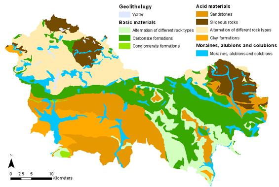
The Pyrenees mountain range is the result of the Alpine orogeny and the collision between the micro plate of Iberia and the European plate. The high granitic peaks of the Axial Pyrenees originated in the Palaeozoic era and the Inner Pyrenees ranges are calcareous sedimentary material (Mesozoic rocks) which originated from marine sediments. The highest calcareous mountain in Europe (Monte Perdido, 3355 m) is inside the study site. Quaternary materials were accumulated in the bottom of the valley, and suffered different erosions and deposits coming from glaciers (moraines, alluviums and colluviums deposits). The eastern part of the area is of great geological interest and scientific importance and has been denominated as 'Sobrarbe Geopark', by UNESCO.
 |
 |
 |
Soils are generally Entisol and Inceptisol. Acid materials dominate more than half of the study area. Quaternary deposits exhibit very low erosion resistance and plutonic rocks (granite and quartzite) the highest. Clay formations and marls also have lower erosion resistance than limestone and sandstone.
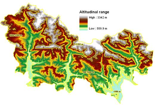
The study area is mountainous with 20% of its surface above 2,200 m and 35% between 1,600-2,200 m. Valley bottoms are at an elevation between 550-900 m (5.3% of the area). The 45% of the area has SE-S-SW orientation and the 31% is oriented to the NE-N-NW. Slopes are generally up to moderately steep (<30°; 60% of the study area), steep (30-50°; 37% of the area) and very steep (3.5% of the area).
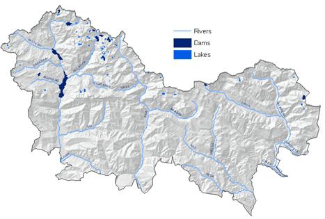
The main rivers are the Gallego, Ara and Cinca, which feed into the Ebro river, in a North-South direction. Maximum flows occur in May and June and lowest in August and September.
Ecosystems and land use
 |
In the study area the altitudinal gradient has an important influence in vegetation and land cover uses; around 35% is covered by forest in the low lands, surrounding the urban and cultivated zones and occupying a little area near the main rivers. Other 13% is occupied by transition communities like boxwood (Buxus sempervirens) with "erizón" (Echinospartum horridum), or junipers (Juniperus commuunis). As elevation rise, above tree line, subalpine grassland is dominated, as around the half of the study area is covered by them. In lower areas, in deep soils and low slopes, dominates the dense grasslands or natural pastures. Sparse grasslands and rock dominate the steep high slopes, with glaciers and natural lakes near mountain tops.
Since the 1980s, land cover in the area has changed significantly, primarily by expansion of forests and the reduction of natural grass and cultivated areas, following abandonment by the shrub encroachment. 62% of the area is under some form of protection for biodiversity, as Sites of Community Interest (SCI), Special Protection Areas (SPA) or the Ordesa-Viñamala Biosphere Reserve (UNESCO Man and Biosphere Program). |
Population, income and employment
The study area has around 6,000 inhabitants, losing more than half of its population during the 20th century, particularly since the 1930s. Population dynamics vary between municipalities, with larger municipalities showing limited growth and smaller settlements at risk of disappearance through abandonment. The study area has extremely low population density (the lowest of Aragón and one of the lowest of Spain) with 4.4 inhb./km².
Municipalities with more balanced and positive population (Sallent de Gallego and Bielsa) have pyramids that show very aged population. Others present a very unbalanced structure, with predominance of men over women and almost absence of young population. Women's emigration is higher than that of men. Overall population growth is negative and modest growth during the last decade is attributed to immigration rather than increased birth rates. The area presents more elderly population and larger average age in comparison with the province of Huesca and Aragón Community.
The economic structure of the area largely follows the population dynamic. Among study area municipalities, Fanlo with lower population density has the lowest GDP per capita (10,000-12,000€) and Sallent de Gallego, with the highest population density, has an income well above the average of study area and Aragon (> 20,000€).
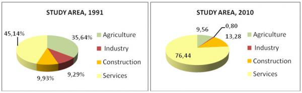 |
In the last 20 years the service sector related to tourism (ski resorts and national park) has risen as the dominant economic with the decline of agricultural activity. The industrial activity has virtually disappeared. |
The study area includes 3% of the territory of Aragon Autonomous Community but receives 33% its tourists. Rural tourism and camping are prevalent in the Sobrarbe (62%) while the area of Alto Gállego is dominated by hotels (69%).
Infrastructure
The area is adequately covered by roads. Social infrastructure includes medical clinics in all municipalities except Fanlo. Only 4 out of 11 municipalities have primary schools.
Particular LEDD issues in Central Pyrenees and responses made
The ageing and decreasing of the population has resulted in the abandonment of the agro-pastoralism activities and changes from agro-pastoralism to tourism services. Also extensive ovine grazing is therefore being replaced by bovine as it required less manpower and it is well adapted to stables. As well from 1986 onwards, the EU Common Agricultural Policy has been the main force in shaping the Spanish agricultural system. As a result of these socioeconomic changes, the mountain and especially pastures are less used and leads to woody encroachment of those. Furthermore, these changes were exacerbated by climatic warming.
 |
 |
There are many responses that are or can be made in the future, actively or unplanned to the LEDD problems; to woody encroachment of the open lands and the problems involved the encroachment. Farmers interviewed as part of the LEDDRA project propose a variety of solutions; directly in the lands proposed prescribed fires or mechanical removal to eliminate the shrub, increase the livestock rate and diversify the livestock species, as well as use more the mountain in diverse aspect. Social response may can from changes in laws, more interactions between the stakeholders from all sectors, or doing applied research help we understand the circumstances. The economic response is related with increase of prices of their products, construing more infrastructures or relates with the subventions, all to put a stop to LEDD problems.