Study sites in cropland
Study sites in grazing land
Study sites in forests
General description of Montesa
| Authors: | Artemio Cerda, Félix González Peñaloza |
| Editors: | Alexandros Kandelapas, Vassilis Koutsoukos, Jane Brandt |
Editor's note 11Feb13: Source D131-4.5
 |
Location Montesa covers 48.1 km² at the southwest of the Valencia province. Its distance form the cities of Valencia and Xátiva cities is 70 and 13 km respectively. Montesa is the major center of the La Costera region, benefiting from acce4ss to both the freeway and railway networks, connecting it with the rest of province. Climate Average annual rainfall is about 550mm with a seasonal peak in spring and autumn (between 150 to 200 mm). Air temperature is generally mild (about 16 °C) with maximum monthly mean in July (24.5 °C) and minimum in December-January (9 °C).
|
Topography and hydrology
Montesa's topography is characterized by an altitude ranging between 200 to 300 meters in the floodplain (about 40%) and an altitude ranging between 400 to 600 meters in the uplands (about 30%). The floodplain (lower altitudes) is dominated by crops while the valley sides are covered primarily by natural vegetation.
 |
 |
 |
The most common aspects are Southeast (22.53%), East (17.35%) and South (13.16%), while flat aspects are absent. The territory is generally steep and moderately steep (45%), followed by both rolling (17%) and undulating (about 30%) landforms.
Hydrologically, Montesa is characterised, on one hand, by dense water networks in northwest and southeast areas with steeper slopes and on the other hand, the sparse hydrological network of the floodplain.
Ecosystems and land use
The area is dominated by Forest ecosystems located in Valley sides (70%) and Cultivated areas located in the floodplain. Drylands cover about 1.50%.
 |
 |
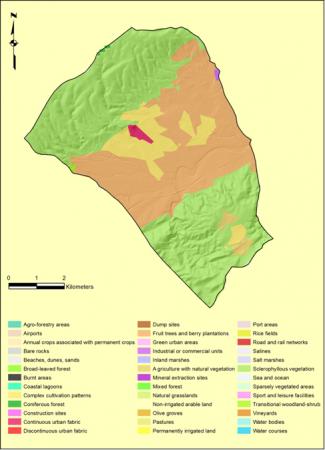 |
According the CORINE land cover typology, the area is primarily covered by Sclerophyllous vegetation in the valley slopes (54.52%) and Fruit trees and Berry plantations in the flodplain (34.41%).
Population, employment and infrastructure
Montesa has had a modest population increase in the last 14 years, while population has grown only 2% in the late 19th century and early 21th century. The area has a low population density from 1996 to 2010. Population density is 28.13 people/km².
 |
Both birth and death rates are decreasing. The population pyramid displays lower percentages of young population (14.46%). People between 16 and 65 years old are 68.81% and aged 65 and over are 16.73%. Montesa has an average birth rate of 8.95 ‰ at least between 1996 and 2010. Dependency ratio in Montesa municipality was 47.4% in 2010, varying from 45.9% (2005) and 55.4% (2000). The latest value for dependency ratio in Font de la Figuera was 57.6% as of 2010. Over the past 10 years, the value for this indicator has fluctuated between 54.3% (2008) and 58.6% (2000). |
In recent years, employment in the tertiary sector has been increasing, while employment in the primary and construction sectors has been decreasing. Overall Montesa has lost about 1% its labor force between 2005 and 2009. Unemployment rate for women is larger than that for men.
Fruits orchards cover over 85% of Montesa’s agricultural area. Ownership is the principal land tenure (about 70%) and the majority of Utilized Agricultural Areas are about 5 hectares.
Montesa hosts a number of educational and health centers.