Study sites in cropland
Study sites in grazing land
Study sites in forests
General description of Alcoutim
| Authors: | Michiel Curfs, Anton Imeson |
| Editors: | Alexandros Kandelapas, Vassilis Koutsoukos, Jane Brandt |
Editor's note 11Mar13: Source D331-3.5
Location
Alcoutim community is situated on the Portuguese (western) bank of the River Guadiana. It is the north-easternmost part of the Algarve province and extends over 576.57 km². Alcoutim is situated on a plateau with a maximum altitude of 250 m. Its boundaries are the River Guadiana to the east, the parish of Pereiro to the west, Mιrtola to the north and Odeleite to the south.
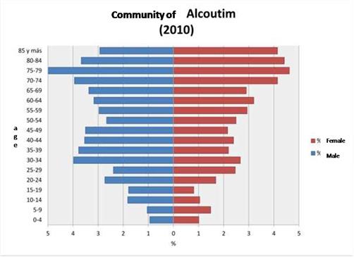 |
Population, economy and infrastructure The population of Alcoutim County in 2001 was 3,770, down from 4,521 in 1991. Ageing in Alcoutim is a serious. Total dependency was 89.7% in 2000 and 87 in 2010. Youth dependency was 14.3 in 2004, 26.3% in 2008 and 13.7% in 2010. The Alcoutim county is generally poor and has purchasing power about half that of the Portuguese average. |
Alcoutim has a medical centre (2 doctors per 1,000 inhabitants). The county also has a primary school. The county also has a local council of social action to identify social problems and provide solutions, among which a home medical examination service, a home help service and free public transport once a week, for persons living outside the town.
Particular LEDD issues in Alcoutim and responses made
The main problems are depopulation, ageing and socio economic problems. Environmental problems such as erosion and desertification are not a priority.
Local formal and planned responses are directed towards social and economic issues.