Study sites in cropland
Study sites in grazing land
Study sites in forests
General description of Paranymfi
| Authors: | Helen Briassoulis, Costas Kosmas, Thanasis Kizos, Minas Metaxakis, Mina Karamesouti, Katarina Kounalaki |
| Editors: | Alexandros Kandelapas, Vassilis Koutsoukos, Jane Brandt |
Editor's note 4Mar13: Source D231-4.5
 |
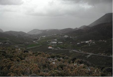
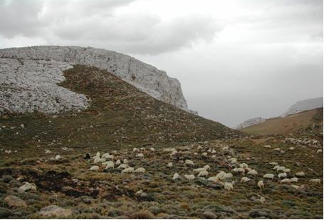
Location Paranymfi community is located in the eastern part of Asteroussia Mts at an elevation of 520 m above sea level covering an area of 2193.1 ha. Total population is around 300 people living mainly from livestock activities. The nearby Ambas location (elevation 800 m) is popular with tourists. Community land is highly degraded due to overgrazing. |
Climate
The largest parts of the area receive between 750-1000 mm (44%) and 1000-1250 mm (31%) of annual rainfall. The southern part (12% of the area) receives an annual rainfall ranging between 500-750 mm while around the Kofinas peak rainfall exceeds 1250 mm. Annual air temperature ranges between 15-18°C, rising above the mean in the southern part and falling at higher altitudes. Annual potential evapotranspiration is estimated at 1481 mm, while maximum ETo values occur during July with an average daily value of 7.1 mm.
 |
 |
Geology, topography, soils and hydrology
The main geological formations consist of limestone (38%), and flysch (62%). Limestone or limestone-flysch is mainly found in the southern part of the community while Flysch or flysch-limestone geological materials are mainly found in the northern part of the community.
 |
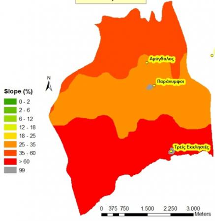 |
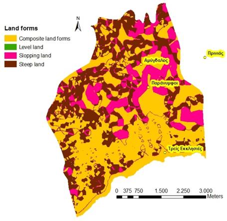
The area is characterised by steep slopes and gorges. Dominant elevation class is 400-600 m (34%), followed by classes 0-200m (12%) and 200-400m (10%). 12% of the area rises over 800 m. Dominant types of landforms are composite landforms (49%) and steep land found mainly in the north-western part of the community (31%). Sloping land covers 20% of the area, mainly found in the central-eastern part of the Paranymfi community. The south part of the community has slopes exceeding 60% mainly while in the north slope class is mainly 35-60%. Slopes are less steep in the central part of the community.
 |
Soil orders are primarily Leptosols (62%) and Cambisols (38%). Soils of the area are residuals soils formed on flysch and limestone, and moderately fine-textured throughout Paranymfi. Soils are moderately degraded in the Paranymfi community compared to Kapetaniana community. Dominant soil depth class is 15-30 cm (61%) followed by moderately deep soils 30-60 cm found in the central part of the community (38%). Advanced erosion lead to the presence of high amounts of rock fragments in the soil surface: rock fragment content is 40-60% in 62% of the area, and 15-40% in the rest. Soils are very well drained due to the shallow depth and steep slopes in which soil water is quickly drained.
The community of Paranymfi is crossed by ephemeral channels with deep gradient, carrying surface water runoff during high rainfall events. Also some subsurface water flow is observed supplying water into channels during the wet period. Existing channels have relatively low density due to relatively impermeable parent (limestone). Channel density is higher in areas with flysch parent material. |
Ecosystem and land use
Paranymfi is a dry land ecosystem with few mountainous areas in its western part. Dry land covers 97.2% of the total area. The whole of Paranymfi is situated in a NATURA 2000 site, as habitat the unique Gypaetus barbatus. Land cover is primarily sclerophyllous vegetation, classified either as natural grasslands (45%) or sparsely vegetated areas (39%). Cultivated agricultural areas do not exceed 9% of the area (vineyards and complex cultivation patterns).
The larger part of Paranymfi is private grazing land, with a small percentage (9%) of olive trees and vines.
Population, employment and education
The population of Paranymfi is 318 people. Population density has decreased in 2001 was 70.1 inhabitants per km². More males are found in the 0-44 and 70-85+ age groups and more females in the 45-69 age groups. Very few young people live in Paranymfi: the population aging rate in 2001 stood at 136.7. The total dependency ratio was 63% in 1991 and 58 % in 2001.
|
In Paranymfi, around 70% of the population is employed in agriculture (stockbreeders and farmers). Most residents have received primary education (41%), while 16% have not finished primary school and 11% are illiterate. 3% are university graduates Infrastructure No schools operate in Paranymfi. The nearest health center is in Harakas. Particular LEDD issues in Paranymfi Paranymfi community faces significant soil erosion problems due to shallow soils, steep slopes, low vegetation cover, and adverse climatic conditions. The majority of soils in the community are moderately eroded, while slight erosion is evident in patches where limestone has been exposed on the soil surface. Paranymfi area is either critical (49%. South and east) or fragile (51%, central and north)) with respect to desertification. |
 |