Study sites in cropland
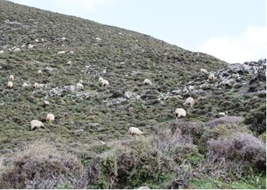
Study sites in grazing land
Study sites in forests
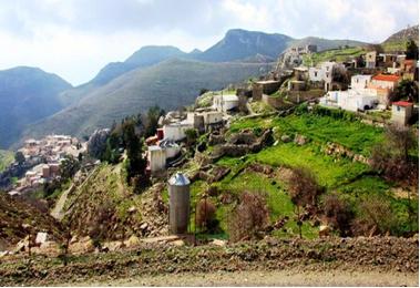
General description of Kapetaniana
| Authors: | Helen Briassoulis, Costas Kosmas, Thanasis Kizos, Minas Metaxakis, Mina Karamesouti, Katarina Kounalaki |
| Editors: | Alexandros Kandelapas, Vassilis Koutsoukos, Jane Brandt |
Editor's note 4Mar13: Source D231-4.4
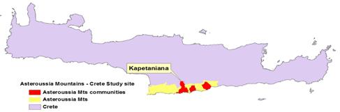 |
Location The community of Kapetaniana is located in the center of the Asteroussia Mountain study site, covering an area of 3523.3 ha. It is part of the Municipality of Gortyna. |
Climate
The surrounding low elevation area receives an annual rainfall ranging between 500-750 mm (22% of the area), while 34% of the area receives annual rainfall ranging between 750-1000 mm. The majority of the area has average air temperature ranging between 15-18°C 60% of the area), rising at the lowest southern part of the community to 18-21°C. The peak of Kofinas has the lowest air temperatures (12-15°C). The annual potential evapotranspiration is estimated at 1481 mm.
 |
 |
Geology, topography, soils and hydrology
The main geological formations consist of limestone (37%), and flysch (63%). Limestone or limestone-flysch is mainly found in the southern part of the community while Flysch or flysch-limestone geological materials are mainly found in the northern part of the community.
The area is characterised by steep slopes, very steep cliffs and steep channels transporting overland rainwater Altitude is ranging from 0 to 1231 m, at the Kofinas peak. Low range of elevations of the community favors the growth of typical Mediterranean machia vegetation. 26% of the community has an elevation between 600-800 m and 19% an elevation between 400-600 m. Low elevation classes 0-200 m and 200-400 m cover 22% and 14.% of the area. Dominant slope class is 35-60% and is found mainly in the northern part of the community, while some slopes greater than 60% are found in the southern part of the community.
The dominant landforms are composite landforms (51% of the area) and, to a lesser extent, sloping land steep lands. Some level land (gradient less than 8% and relief difference less than 50 m) is located at the southern part of the community.
 |
 |
The dominant soil order identified is Leptosols. Soil texture is closely related to the parent materials flysch and limestone which have favored the formation of moderately fine-textured soils. In few cases soil texture is characterized as coarse or medium depending on the presence of sandstone or siltstones layers on the soil surface or high degree of erosion. Kapetaniana community soils are highly degraded. The dominant soil depth class is 15-30 cm (64% of the area, mainly in the northern part of the community), while 36% of the community' area has soils less than 15 cm deep. Soil surfaces contain high amounts of rock fragments, primarily due to the advanced degree of erosion. The dominant class of rock fragment content is 40-60% is the dominant class in the area (93%). No areas of free of rock fragments. Soils are very well drained due to shallow depths and steep slopes favouring quick water removal.
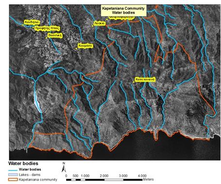
The area of Kapetaniana community is crossed by ephemeral channels with deep gradient, carrying surface water runoff during high rainfall events. Some subsurface water flow is also observed supplying water into channels during the wet period.
Ecosystems and land use
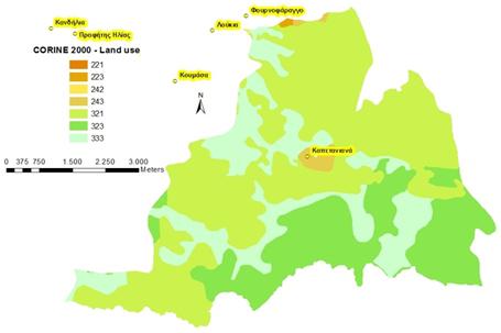 |
Kapetaniana community is a dry land ecosystem. The whole area of the Kapetaniana community falls within the NATURA 2000 site, as a habitat for Gypaetus barbatus. Land cover types are classified as natural grasslands (52%), sclerophylous vegetation (25%) and sparsely vegetated areas (22%), although the "natural grasslands" category also refers to sclerophyllous vegetation. The larger part of Kapetaniana is covered with cultivated areas and fallow land. Cultivated land includes olives and vines and faces serious irrigation problems. About 10% of grazing lands are private. |
 |
 |
 |
Population, employment and education
The population of Kapetaniana is 719 people, having decreased slightly since the 1960s and increasing 10% in 1991-2001 period. Population density is 102.1 inhabitants per km² (2001). The male population is slightly higher in the 0-40 age groups and while more females are observed in the 41+ age groups. Percentages of young people are low, a result of low birth rates, low death rates and longer life expectancy rates. Population ageing in Kapetaniana follows the general Asteroussia trend: ageing rate was 115.5 in 1991 and increased to 152 in 2001. Total dependency ratio was 73.5% in 1991 and increased to 73.7 % in 2001. The percentage of population aged 0-14 years was 6% in 2001.
Over 70% of the economically active population is employed in the primary sector, with less than 10% employed in (small scale) industry. Employment in the tertiary sector decreased from 18% in 1991 to 13% in 2001. Unemployment is limited.
Most residents have received primary education (46%), while 11% have not finished primary school and 10% are illiterate. 6% are university graduates
Infrastructure
Kapetaniana has one primary school. The nearest kindergarden and high school are located in nearby Vagionia and the lyceums in Agioi Deka and Moires. Student transportation is a problem. Residents are served by Harakas health centre.
|
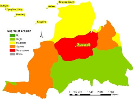
Particular LEDD issues in Kapetaniana Kapetaniana community faces significant soil erosion problems due to shallow soils, steep slopes, low vegetation cover and adverse climatic conditions. Soils are slightly eroded (36%), severely eroded (30%), moderately eroded (20%) and very severely eroded (14%). Erosion problems are found mainly in steeply sloped areas of the northern part of the Kapetaniana community, especially in soils formed on flysch. The largest part of Kapetaniana community is either sensitive (26%) or critical to desertification (74%), particularly in the south, which is already characterised by a high degree of desertification. |
 |