Study sites in cropland
Study sites in grazing land
Study sites in forests
General description of Asterousia SES
| Authors: | Helen Briassoulis, Costas Kosmas, Thanasis Kizos, Minas Metaxakis, Mina Karamesouti, Katarina Kounalaki |
| Editors: | Alexandros Kandelapas, Vassilis Koutsoukos, Jane Brandt |
Editor's note 4Mar13. Source D231-4.3.
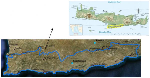 |
Location The Asteroussia study site consists of the Asteroussia Mountains located in southern Crete, bordered to the north by the Messara valley and to the south by the Libyan Sea, covering an area of 38,428.8 ha. |
Climate
At lower elevations the Asteroussia Mts receive annual rainfall ranging between 500-750 mm (approximately 30% of the area), while higher mountainous areas receive up to 1250mm (around 5% of the area). The majority of the area (53%) receives rainfall ranging from 750-1000 mm.
The area has average air temperature ranging between 15-18°C, slightly higher in the lower western and southern part (around 21°C) and lower (12-15°C) in the upper parts. Annual ETo is estimated in 1481 mm.
Geology, topography soils and hydrology
Geologically, the Asteroussia Mts consist mainly of limestone (38.5%) and flysch (54.2%).
Topographically, they are characterised by steep slopes, very steep cliffs and steep channels transporting overland rain water. The highest peak, Kofinas, rises to 1231 m. About 22% of the area has elevation ranging from 0-200 m and about 36% has elevation of 200-400 m. Elevations above 800 m cover only around 5% of the area. Slopes are generally 35-60%, covering about half of the Asteroussia Mts, while 22% of the area has slopes greater than 60% and 21% of the area has slopes of 25-35%. The Asteroussia Mts are covered by composite landforms and level land (44% of the area), sloping land (26%) and steep land (30%).
 |
 |
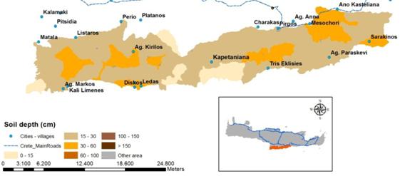
The major soil orders in the area are Leptosols (almost 79% of the area) and Cambisols (almost 21%). Soil is predominantly fine textured (84%) and to a lesser degree medium textured (16%). Soils are highly degraded, with the dominant soil depth class being 15-30 cm (70% of the area) with few patches of deeper soils (class 30-60 cm). Very shallow soils are found especially in the south-facing slopes of the souther part of the mountains. Asteroussia soils have high amounts of rock fragments: 57% of the area falls in the 40-60% rock fragment content class and 43% in the 15-40% class. Soils are very well drained, mainly by small ephemeral channels carrying surface water runoff. Existing channels have high densities due to the impermeability of parent materials.
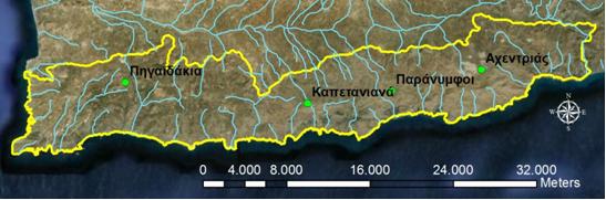
The Anapodaris River crosses the eastern part of Asteroussia Mts. It is the longest river of Crete with a total amount of flowing water estimated to 40 million cubic meters.
Ecosystems and land use
The area is a dry land ecosystem (almost 92%), with few cropland areas (approximately 8%) for olive and cereals production and greenhouses. Βiomass production is restrained by water deficiency. 72% of the area is a NATURA 2000 site as habitat of Gypaetus barbatus.
The most important land cover types are natural grasslands, sclerophylous vegetation, transitional woodland-shrub, and sparsely vegetated areas.
Dominant land use is grazing (60% of the area, 94% private and 6% state owned). However, due to the lack of a cadastre, results in conflicts. Forest areas are limited in Asteroussia (around 2%).
Population, employment and education
The population of the Asteroussia has decreased steadily over the last 60 years, despite the overall population increase of the Crete and the former Herakleion Prefecture. Population density has decreased from 23.2 inhabitants per km² in 1961 to 17,7 inhabitants in 2001. Population pyramids are cone shaped, with low birth rates and many people in the 55+ age groups, particularly women. Ease of access to the city of Heraklion, has added to depopulation, as many choose to live in the city and visit the area regularly. The total dependency ratio stood at 66% in 1991 and at 70% in 2001, much higher than the average of the former Heraklion prefecture (48%).
Although in decline, the primary sector remains the dominant activity with employment in the services sector increasing very modestly. Employment in the agricultural sector is 35.1% despite a sharp decline of 21% since 1991. Other sectors are less important: 7% employment in small scale trade and services, 2% in hotels and restaurants, 4% in scientific services, 4% in manufacture, 3% in wholesale, retail trade and repairs. Unemployment has doubled since 1991.
Educational level is generally low: most inhabitants have received primary education (44%) or no schooling at all (25%).
Administration and infrastructure
Administratively, the study site is part of the former prefecture of Heraklion, now the Herakleion regional unit, of the region of Crete. The Regional administration is seated in city of Heraklion. The area includes 14 municipal districts, forming part of 4 municipalities (Faistos, Gortyna, Archanes-Asteroussia, Minoa Pediados)
Six kindergartens, 10 primary schools and 1 high school operate in the area but not any lyceums (Table 4.17). The area is served by two rural clinics, but residents tend to travel to Heraklion for health purposes (2 hospitals).
|
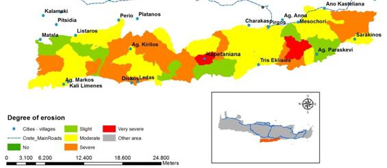
Particular LEDD issues in Asteroussia Natural vegetation in the area is threatened by overgrazing and wild fires, ignited deliberately or accidentally. These occurrences in combination with the steep slopes, render soil erosion a major issue of land degradation and desertification in the Asteroussia Mts. Several parts are severely (32%) or very severely eroded (4%). Slightly eroded areas cover 17% of the area and moderately eroded soils 47%. |
|
Environmental and socio-economic impacts of erosion include loss of fertile topsoil, decrease in water storage capacity, loss in organic matter content, loss in biodiversity, decrease in plant production, exposure of large amounts of rock fragments on the soil surface, land desertification, lower farm income and flooding in the lowland accompanied with infrastructure damages.
Under these extreme conditions of land degradation, plant production is reduced drastically leading to land desertification of the area. The southern part of the area has a higher degree of desertification and almost all of the rest of the area is characterized as critical to desertification.
Responses to LEDD are primarily legal/institutional and advanced through national policies, with a very low degree of local enforcement.