Study sites in cropland
Study sites in grazing land
Study sites in forests
General description of Stella Cilento
| Authors: | Gianni Quaranta, Rosanna Salvia |
| Editors: | Alexandros Kandelapas, Vassilis Koutsoukos, Jane Brandt |
Editor's note 11Feb13: Source D131-3.4
Location and history
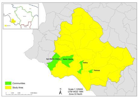 |
Stella Cilento covers an area of 14.38 km² and is located in the western part of the province of Salerno. Mount Stella has long been a place of refuge for local inhabitants because of its rich natural resources and so was a natural choice to start small communities which today make up the Municipality of Stella Cilento. These communities include the villages of San Giovanni, Amalafede, Guarrazzano, all founded in the early 1000s. |
In Napoleonic times and with the fall of the feudal system, the small inhabited centers in the area were united and Porcili, the largest of these centers, became the chief town of the area. The economy of Porcili was based on agriculture and the trading of typical local produce including the local black pig.
By the late 1800s with government funding for public works, the area was receiving significant numbers of migrants.
Since the 1950s, Stella underwent profound change caused by the preceding World wars, emigration and the embourgeoisement of local society: continuing influx of migrants facilitated a construction boom and the gradual decline of the agricultural sector.
Topography, soils and hydrology
Stella Cilento’s altitude is around 400m, 77% of the territory being covered by coastal hills and 20% by marl-arenaceous and marl-calcareous mountains. Prevalent aspects are East, (17.72% of the area), Northeast (16.37%), Southeast (15.72%) and South (15.52%). Prevalent slope gradient is above 50%, (40% of the area), followed by slope gradients of 30-50%, (35%) steep (25-35%, 75,5% of the total area) and very steep classes (35-60%, 20% of the area).
There are 18 examples of active landslides in the area, affecting an extension of 14 hectares that is 1% of the territory.
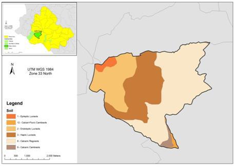
Dominant soil types are Calcari-regosol, (47%) and Haplic Luvisol (29%). The dominant parent material is Flysch (99.3% of total area) and the textural class is primarily moderately fine (71.5% of the area). Soil depth is generally moderately deep (60-100cm, covering 67.2% of the total area) or deep (100-150 cm, 30% of the area), with rock fragments presence between 20% and 40% (69.4% of the area). Soils are well drained (70.8%) and moderately well drained (29.2%).
 |
 |
Stella Cilento area limits include several water courses which flow into the Alento at the point nearest the source. The presence of plateaus in the area shape the course of the water so that it flows directly towards the sea and funnels into the Alento almost in correspondence with the mouth of the river.
Ecosystems and land use
Ecosystems are primarily Cultivated (coastal hills), Forest, in mountainous areas and Dry land (in the southernmost part). Stella Cilento is situated inside the National Park of Cilento and Vallo di Diano, also bordering on the Site of Community Interest (for biodiversity), Mount Stella. Around 42% of the territory is covered with Broad-Leaved Forests, while Principally agricultural land with natural vegetation covers 40% of the area (considerably higher than the coverage in the Alento study area). Over 40% of agricultural land is covered by olive groves.
Population, employment and income
From 1861 to 2010 the population has more than halved and population density has fallen from 96.68 inhabitants/km² in 1961 to 59.19 inhabitants/km² in 2001. The community of Stella Cilento is more affected by depopulation than the Alento study area as a whole. Average age of residents, has increased affecting both the elderly index (quadrupled in the last forty years) and the elderly dependency rate.
Over half of the population lives in detached houses in the countryside, and in the towns and villages that encircle Stella Cilento. Data for Stella Cilento show an increase both in occupied and un-occupied houses throughout the years.
Employment in agriculture has declined whilst employment in other sectors has increased. Over the years figures for self-employed and salaried workers have remained largely stable. The value added per capita for the municipality of Stella Cilento for 2009 is higher than the average value for Alento.
The social fabric of the area has changed considerably over time with the nationality profile of foreign residents from 1999-2007 showing a wide range of different nationalities resident in the area. Only recently, net migration started exhibiting decreasing trends.
The percentage of the resident population completing school and continuing with further education, the literacy rate and employment-to-total-resident-population ratio have also increased. The poverty index for Stella Cilento, shows the study community has lower yearly consumption per capita than the national but considerably higher than the Alento study area average.
 |
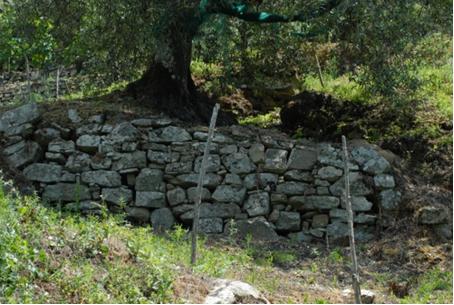 |
Particular LEDD issues in Stella Cilento
The principal LEDD problem facing the community of Stella Cilento is soil erosion which casues damages in terms of reduced agricultural productivity and, in the most severe cases, leads to landslides that pose a serious threat to local infrastructure. Given the hilly terrain of this community, slope instability due to collapsing terraces is a significant threat. For the cultivation of olive groves in the type of terrain that characterises Stella Cilento dry stone wall terraces are usually favoured over embankments. Sustained soil erosion and poor maintanence can lead to a relatively sudden collapse of these walls which risks eradicating the soil’s top fertile layer. Due to the fragmentated nature of cultivated land in this hilly community and the encroachment of abandoned olive groves to forest land, fires originating in wooded areas are susceptible to spread to surrounding crop-land or vice-versa.