Study sites in cropland
Study sites in grazing land
Study sites in forests
General description of Petrosa
| Authors: | Gianni Quaranta, Rosanna Salvia |
| Editors: | Alexandros Kandelapas, Vassilis Koutsoukos, Jane Brandt |
Editor's note 11Feb13: Source D131-3.7
Location and history
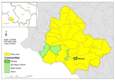 |
The town of Petrosa is part of the municipality of Ceraso and has a surface area of around 1.36 km², making up around 3% of the municipality (46 km²). It is situated between the rivers Palistro and Badolato, at around 130m a.m.s.l. The town was developed after the reclamation of the area of Fabbrica and the subsequent re-allocation of land of 1891. Since the beginning of the 20th century farming, the social balance of the town was disrupted by successive waves of emigration and the two World Wars. Today Petrosa is largely depopulated as well as isolated due to the poor road network. The majority of farmers work small areas of land, there are few large farms and extensive farming is predominant. One exception to this rule is a local farm of 55ha operating for more than 50 years which has expanded to agro-tourism. |
Climate
The average altitude at Ceraso (to which Petrosa belongs) is around 340m a.m.s.l, with an altitudinal range of 1007 m. Average annual rainfall in the area is 3.47 mm/year, with the wettest month being November and the driest month July.
Mean monthly temperatures vary between 9° and 25°C. Maximum temperatures vary between 13° and 32°C and minimum temperatures vary from 5° to 19°C. The hottest month is August and the coldest February. Evapotranspiration is higher in the summer months and lower in winter months.
Topography, soils and hydrology
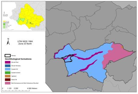
Petrosa is predominantly made up of alluvial plains crossed by Apennine Rivers, covering 60% of the area. The highlands are characterized by coastal hills. The area is generally flat and of low altitude generally not exceeding 250 m a.m.s.l. The most common aspects are west and southwest (18%) and Northwest (17%). The prevalent slope gradient is under 8% (35%), followed by slope gradients of 8-15% (21%). In the eastern part of the community there is some highland, with higher slope gradients, reaching over 50%.
 |
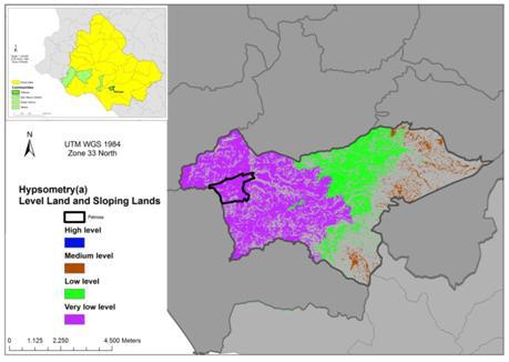 |
With respect to landforms, Ceraso is prevalently covered with Level land, Steep land (inland areas) and Slopping land (with gradients between 8% and 30%) in the South of the study community. The sloping lands, however, are characterized by slope gradients of between 8-30%. Some Steep and sloping lands, (slope gradients over 30% and altitudes over 600), are found in the mountainous areas of the municipality.
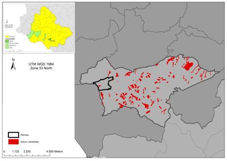
The area is Strongly dissected and Dissected on the flat land around the town of Petrosa, Mostly Dissected in central areas and Slightly Dissected in the remainder of the municipality. Although Petrosa has one active landslide, the surrounding Ceraso municipality has more than 270 active landslides, affecting 361.72 hectares (8% of the municipality).
 |
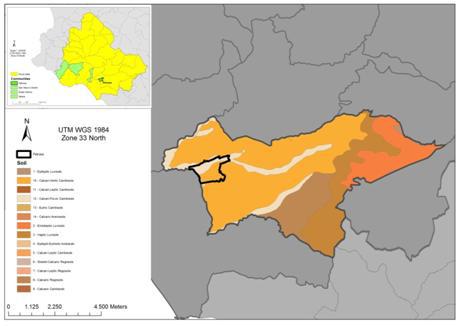 |
The town of Petrosa has a high presence of Calcari-Vertic Cambisols (56%), and also Calcari-Fluvic Cambisols (44%). A variety of parent materials such as Flysch, limestone, clay (56%), alluvium (44%) and sand are found in the area. With regard to texture, soils are generally fine (56%) and moderately fine (44%). Soils are moderately deep or deep with presence of rock fragments lower than 40%. The whole are is well drained.
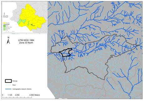
Petrosa is crossed by effluents of the Alento River.
 |
 |
Ecosystems and land use
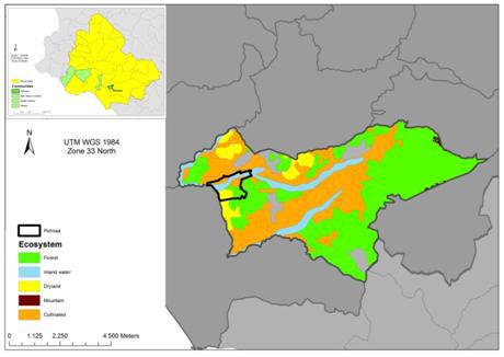
Ecosystems in the area are Forest (in mountainous areas), Dry land (inland), Inland Water, and Cultivated, present in the majority of the area and shares the characteristics of cultivated coastal hills. Petrosa is included in the National Park of Cilento and Vallo di Diano, while on the border with Castelnuovo Cilento there is also an EU S.I.C (Sites of Community Interest); the Alento River.
Land cover is primarily Annual Crops (40%), Principally agricultural land with natural vegetation (13%) and Permanent Crops (less than 2%). Significant part of Ceraso is Mixed Forest (25%) and Sclerophyllus Vegetation (23%)
Population, employment and income
Ceraso has a population density of 64 inhabitants/km², which has decreased significantly over the years, alongside that of the Alento study area as a whole. Average age of the population is also rising. The total dependency index has increased, as has the elderly index, which is, however, lower than that of Alento.
The value added per capita for the study community for 2009 results lower than the average value for Alento. VA for the study community is principally derived from agriculture.
The area has received significant immigration during the 1990s and 2000s primarily form the EU and Africa.
Employment figures for the study community are in line with those for Alento with a significant decrease of people in employment over the last decades time. Nevertheless, the employment-to-total-resident-population ratio is increasing.
The estimated Human Development Index (HDI) for the study community is in line with the Alento area but slightly lower than the national average. The poverty index for Petrosa is lower than that of the Alento study site and the national average.
Particular LEDD issues in Petrosa
The community of Petrosa is characterised by moderately intensive farming practices which protect it from some of the LEDD issues threatening other communities on the alluvial plain of the study site. Isolated cases of nitrate pollution do persist, but as a whole Petrosa should is an area of moderate risk. The expansion of sustainable tourism industries in the community has also alleviated some of the pressure placed on local natural resources and shifted economic focus away from intensive farming practices.