Study sites in cropland
Study sites in grazing land
Study sites in forests
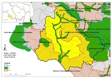
General description of Alento River Basin SES
| Authors: | Gianni Quaranta, Rosanna Salvia |
| Editors: | Alexandros Kandelapas, Vassilis Koutsoukos, Jane Brandt |
Editor's note 11Feb13: Source D131-3.3
Climate
The study area is characterized by a relatively temperate climate with mild winters and hot but not humid summers. The area has a Mediterranean climate, temperate with moderate rainfall, especially inland. The amount of annual rainfall is variable. As for temperature, the hottest month is August whilst February is the coldest. The values for mean monthly temperature vary from 8° to 27°C. July has the maximum values calculated on evapotranspiration.
Topography, geology and soils
The landscape of Cilento today still preserves traces of its tumultuous geological past, a past that has played an important role in shaping the current stratigraphy of southern Italy. External Units include Alburno-Cervati-Pollino Unit and Monte Bulgheria Unit, which shows examples of various different formations. Internal Units include Liguride units and the Cilento Group that represents the sequences that are typical of the region. The evolution and morphology of the Cilento region’s countryside is characterised by strike-slip and thrust tectonics with clear geological and kinematic indicators of tectonic activity. This activity has led to the vertical fragmentation of large blocks of the main rock massifs.
The principal units of structural morphology are found in the limestone relief of Mount Cervati, the Mount Chianello – Vesole – Soprano – Sottano ridge and the complex mountain chain of Mount Bulgheria. The terrigenous reliefs found in Mount Sacro, Mount Centaurino and Mount Stella. Between these two areas there are also areas of relative depression associated with Miocenian synorogenic formations. An evaluation of the structural elements shows lineaments with faults that displace structures with a NW-SE direction and NE-SW.
 |
 |
Categories of Landforms identified are level land, slopping land, steep land and land with composite landforms. In the study area, 1607 examples of active landslides in the territory were found, affecting and area of 2940 hectares. The area’s susceptibility to landslides is linked to the geological and morphologic characteristics of the site.
Flysch parent materials cover 71.5% of the total area, followed by alluvium (9.2%).
The area consists primarily of moderately fine textural classes (60.5% of the area), followed by fine textured (20.8%).
Soils are generally moderately deep (60-100cm) (57.2% of the area) or moderately shallow (30-60cm) (18%). The class of rock fragments between 20% and 40% covers 71.6% (39.404 hectares) of the total area. Well-drained soils cover 69.3% of the total area.
 |
 |
Hydrology
The hydrographic network of the area, crossed by the Alento River, is based essentially on two principal watercourses whose waters flow directly from the steep rocky ridges into the bottom of the valley. This particular hydrographic structure, together with the presence of plastic soil, favor land surface degradation that leads to slope instabilities. There are a number of water bodies extending along the area.
Around 120 sinkholes have been surveyed and catalogued in the area, all surveyed are located on alluvial plains and contributing to the water body of the Alento Plain. These sinkholes shouldn’t be considered part of a single underground body of water. Water circulation inside the Alento River basin has been significantly influenced by the construction of numerous weirs and dams that have altered the natural speed of water flow. Of particular significance is the “Alento System”, at the very heart of which is the dam located in Piano dellaRocca. There are several uses for the water: Drinking water, Irrigation, Industrial Use, Un-Treated Water, Hydro-Electricity. Some ecosystems have been identified on the basis of morphological characteristics and the vegetation cover present in the area: Inland water, forest, dryland, mountain, cultivated and urban ecosystem. The transitions in land use registered over the years have not affected a considerable part of the area, but the variations in land cover have been contained and affect only specific categories of land.
Population
Whilst on a regional scale population is increasing, the rural areas, like Alento, are affected by depopulation. Population density has consistently decreased over the years.
According to the ageing index for the townships in the Alento area, the area’s population is ageing significantly, and more so than in the Campania Region. Birth rates are falling and so is the number of young people.
The total dependency ratio decreases less in Alento than in the Campania region as a whole. The elderly dependency ratio has a higher increase in the Alento area whilst the youth dependency ratio again decreases less in the Alento area than in the region of Campania.
Significant migration is directed to the Alento region, although the inflows of non-EU migrants has been decreasing since 2005.
Employment, economy and infrastructure
Total employment in the area decreased by almost 8% in the decade 1991 – 2001.The number of people employed in agriculture falls consistently whilst employment in industry and the other sectors is on the increase. The percentage of Value Added to base prices for 2002-2005 shows significant fluctuations.
The percentage of graduates in the literacy rate increases consistently. Employed population has increased both in terms of percentage and in total numbers of people in employment. The number of people employed in family businesses remains more or less stable whilst the remaining categories fluctuate much more. The HDI for Campania, and all southern regions, shows values increasingly nearing the national value.
The only professional organization that operates inside the study area is Coldiretti, located in Vallo della Lucania. Coldiretti is one of the principal organizations of Italian farmers nationally and also in Europe. Other organizations in the Alento area are FondazioneAlario, Associazione Cilenvallo, GalCilentoRigeneratio, Park communities, Mountain communities and the Alento Water Consortium. The structure of the Italian administrative system is based on the state, regions, province, municipalities and mountain communities. Most of the farms (93%) are owned by farmers.
The majority of houses in all the townships are located in built-up residential areas along the coast, as a result of the expansion of tourism and other service industries.
The road network in the study area consists principally of the state run coastal road, the strada provinciale and the strada statale.
Alento is poorly connected to power distribution networks. Broadband coverage is limited.
In each township there is one or more state nursery and elementary school with the exception of the smallest towns. All townships also have a middle school whilst there is a high school only in Castelnuovo Cilento and Vallo della Lucania. The Vallo della Lucania hospitals are part of the Health District 70.
 |
 |
Particular LEDD issues in the Alento River Basis SES
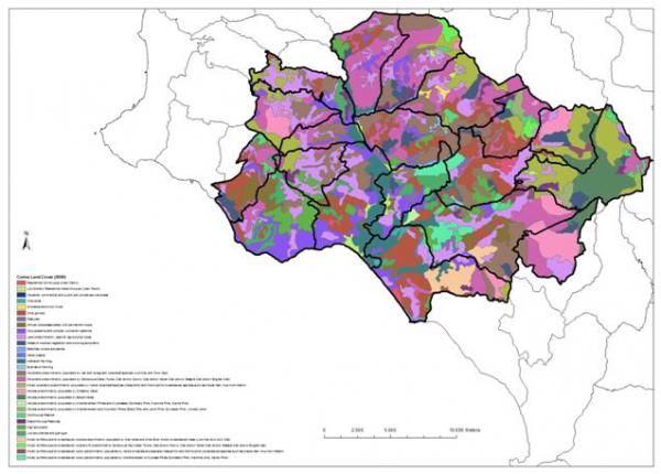
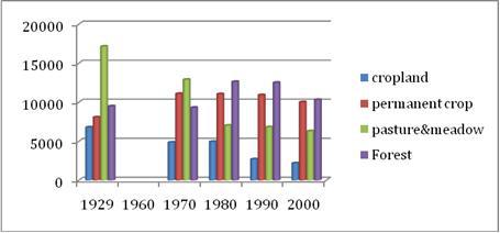
The extension of land in various classes has changed, increasing in some classes and decreasing in others. Woods surface (Mediterranean Pines and Cypresses) is decreasing. Urban areas are expanding, particularly along the coast, due to expansion of tourism and other service industries.
Slope instability is the most easily detectable land issue in the Alento study area, mainly due to its visual impact and its severe biophysical and socio-economic impacts. Reduction of used agricultural surface area, crop selection, socio-demographics and intense depopulation show a progressively declining rate of human intervention which this area so relies upon. Abandonment of agricultural areas, colonized by shrub vegetation, vulnerability to fire and the delicate phase of transition that agricultural land is undergoing at the moment, all contribute to the problem. The de-activation of farming is closely linked to depopulation and to the ageing of the population. Landslides in the Alento study area are mainly triggered by human interference to slope stability.
 |
 |
Policy drivers are also critical. The abandonment of traditional extensive farming practices affects the environment, the local landscape and the social-cultural geography of the area. Half of Alento’s land surface is eroded by more than 0.5 ton/ha, almost 12% of which is over 10 tons per hectare.
Soil sealing, has not thus far been a major cause of concern. However, several increasing trends point to an increasing risk of soil sealing (and higher levels of salinisation and nitrate pollution):
- a flux in population moving from inland areas to coastal areas
- the intensification of agriculture
- the expansion of the tourist industry.