Forests & shrubland
Characteristics of forests & shrubland: Italy and Matera
Editor's note 15Jun2012: Text source D311-2.2
The Italian peninsula occupies an area geographically situated between 36° and 47°30’ North latitude and between 5°30’ and 18°30’ East longitude. Its orography is quite complex due to the presence of two main mountain ranges, the Alps in the north and the Apennines in the centre-south. Due to this geographical and orographical heterogeneity, the Italian climate is also very variable following the latitudinal and altitudinal gradients and the distance from the sea. In general, the Italian climate ranges from Mediterranean warm to temperate cool (Chirici et al. 2007). This variability, combined with a high population density, produces a complex distribution and composition of forests. According to the forest map derived from the CORINE Land Cover 2000 map (Figure 1), forests (including shrubland) cover nearly 9.2 Mha in Italy (Maricchiolo et al. 2004) with 95 percent of forests located in mountainous and hilly regions. Half of the forests (52 percent) is located in the Mediterranean region, 32 percent belong to the Alpine biogeographical region and 16 percent to the Continental region (Habitat Directive of the European Commission 43/92).
 |
Figure 1. Forest distribution in Italy (raster format with geometric resolution of 1 km²). The nomenclature system is an aggregation of the original one, which is derived from the CORINE Land Cover dataset. Forest types classes: 1 White fir/Norway spruce forest; 2 Chestnut forest; 3 Exotic conifer forest ; 4 Beech forest ; 5 Exotic broadleaf forest; 6 Hygrophilous broadleaf forest; 7 Mediterranean broadleaves ; 8 Holm oak ; 9 Bushlands; 10 Mediterranean pine forest; 11 Mountain pine forest; 12 Other oaks. Source: (Chirici et al. 2007). |
Italian forest ecosystems are also characterised by a pronounced biodiversity with 117 native forest tree species. Beech, deciduous and evergreen oaks, poplars and chestnut represent most widespread forest types. The main conifer forests are those of Abies alba and Picea abies, followed by other Pine forests. Fifty-three percent of forestland is managed as coppices, 43 percent as high-stands, and 4 percent is Mediterranean macchia. Even-aged stands represent 60 percent of the total high stands (Corona et al. 2004). Individuals privately own two thirds of Italian forests, in small holdings, and one third is publicly owned, mainly by Regions and Municipalities (FAO 2003).
Mediterranean forests and shrublands represent one of the most important ecological systems because of their rich biodiversity; they are recognized as biodiversity hotspots (Myers et al. 2000). On a continental scale, Mediterranean forests cover only 8.5 percent of the European land area but they host about 25,000 species of vascular plants with a high degree of genetic diversity and endemism (about 50 percent of the species are endemic). Despite this high level of biodiversity, Mediterranean forests and shrublands represent one of the most vulnerable ecosystems with high levels of fragility and instability due to several environmental and human-induced pressures including climate change, recurrent fires, human activities and land use changes.
Mediterranean forests have played a crucial role in the rise and development of some of the oldest civilizations, thanks to their multifunctional environment which offers a wide range of important benefits and services to society and human welfare beyond traditional forest wood products. Over the centuries, a mosaic-like structure emerged from the complex interactions of forests and shrublands with other land uses such as agriculture, pasture and urban or industrial areas. One of the most important forest functions in the Italian territory, as elsewhere, is the capacity to maintain and regulate water and soil resources, protecting watersheds and regulating local climate, generally mitigating severe summer droughts and desertification processes. Other important socio-economic development benefits include protection of soil against erosion and salinisation processes, carbon sequestration, recreation and landscape scenic value, supporting tourism development. These forest services provide more benefits to the local communities than to their individual owners. In fact, the production of wood products based on traditional forestry suffers from decreasing profitability as a result of high extraction costs. This situation leads to general forest abandonment, the consequences of which include increased fire risk and phytopathological diseases. In rural areas, the main threats to forests include overgrazing and forest clearance for agricultural use.
The Basilicata region is located in Southern Italy and its territory includes the 'Mediterranean coastal and upland study site in Matera prefecture' that represents and embodies most of the climatic, environmental and socioeconomic aspects and characteristics of Mediterranean regions.
The Basilicata Region covers approximately 10,000 km². It is located between the Regions of Calabria, Campania and Puglia and also borders with the Tyrrhenian Sea to the west and the Ionian Sea to the south. The Region is mainly hilly-mountainous with a flat area in the south. The mountainous area is essentially in the west, representing 47 percent of the total territory. It includes the Apennine Mountains, which cross the region in a northwest-southeast direction. Mount Pollino (2248 m a.s.l.) is the highest mountain. The rest of the Basilicata Region is characterized by hills (45 percent of the land area) and by plains (8 percent of the land area). The mean annual rainfall varies across the region from 500 mm to 2,000 mm in the southwest. The rainfall is irregularly distributed during the year and between years, as it is common in a typical Mediterranean climate (maximum precipitation in autumn and minimum during the summer). The region is within the annual isotherm of 11°C-15°C (De Stefano and Lorusso 2000).
In the mountainous areas, forestry, agriculture and pastures represent the most important economic activities. Forests cover 35.6 percent of the territory (Figure 2). Oak forests, composed of different species (Quercus sp.), occupy 51.8 percent of the total forest cover, beech (Fagus sylvatica) 8.4 percent, Mediterranean bush 7.9 percent, forest plantations only 0.6 percent, and conifers 7 percent. The altitudinal distribution of forests is as follows: 60 percent are located between 400 m and 1200 m altitude, less than 9 percent above 1200m, and 20 percent is located in less than 400m altitude.
 |
Figure 2. Basilicata Region Forest Map. Source: (Costantini et al. 2006) |
The Mediterranean forests of the Basilicata Region include a range of different types such as pinewood forests of artificial origin located in retro-dune zones, reforestation with Mediterranean pines in the calanchi (“badlands”) and the Mediterranean macchia and garrigue mainly found in the Ionian coastal zones. These habitats represent a fragile environment with a high risk of land and ecosystem degradation.
On the coastline, the pinewood forests are artificial in origin in that they have been planted since the mid-1930s. Major reforestation took place between 1950 and 1970, with Southern Italy Development Funds. The main objective of reforestation was to consolidate the coastal dunes and to create an efficient and wide windbreak strip to protect inland agricultural crops from marine aerosol fluxes. The species most commonly used were Pinus halepensis (the majority), Acacia saligna, Eucalyptus globulus, Eucalyptus rostrata, Pinus pinea and Tamarix gallica. Less used species include Cupressus sempervirens, Pinus pinaster and Pinus canariensis.
One of the main effects of the protective function of coastal reforestation is the development of inland intensive agriculture. Thus, coastal reforestation can be considered as one of the main drivers for the growth of the economic use of the coastal area. The best reforestation results are due to the use of Pinus halepensis (which is native in the Ionian area) rather than Pinus pinea. The forests are 30 to 80 years old, generally even-aged, and they show very different conditions of growth, depending on stand characteristics and thinning. Areas without intervention are often characterized by high incidence of deadwood or trees with poor growth habit and these represent a significant fire hazard. Frequently, phytosanitary problems are also encountered, for example intense attacks of Thaumetopoea pityocampa.
The second forest type is represented by the reforestation of the calanchi (“badlands”) with Mediterranean pines. In this case also, this forest type has been planted for protective purposes. In fact, the erosion phenomenon of calanchi badlands concerns a large part of the Ionian area of Basilicata and the main manifestations are found in Aliano, Craco, Pisticci, Montalbano Jonico, Tursi and other adjacent areas. These erosion phenomena, due to their characteristics, are considered a site of extraordinary geological interest, protected by the institution of Geological Reserves within the natural boundaries represented by the Sauro torrent in the west side and by the Basento river in the east part.
The calanchi badlands principally originate in argillaceous soil, in which the surface water run-off causes a “combined erosion” process represented by channel erosion and repeated superficial slides, resulting in a dynamic sequence of channels separated by crests. In general, the south side of the calanchi badlands are much steeper because of the combined actions of sun and rainwater. The sun desiccates the soil, creating a network of cracks in which rainwater run-off starts the erosion process. The north side of the calanchi badlands are generally characterized by a gentle slope, allowing agricultural practices like olive groves and grazing of natural formations like Mediterranean bush (Figure 3).
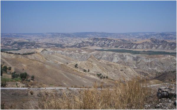 |
Figure 3. Calanchi badlands in the Matera study site. Source: (Author Angelo Nolè). |
In general, the calanchi “badlands” are a very inhospitable environment for vegetation because of steep slopes, instability of the soil, high soil salinity and long periods of drought. As a result, vegetation is sparse and is characterised by plants that can tolerate the salinity and have specific adaptation mechanisms. Main species are Capperis spinosa, Tamarix africana, Spartium junceum, Psolearea bituminosa, Ligeum spartium and Glycirrhiza glabra.
In order to increase the vegetation cover and limit erosion processes, a broad afforestation programme was realised in many calanchi badlands, between1950 and 1960 in particular, using Mediterranean pines like Aleppo pine (Pinus halepensis), stone pine (Pinus pinea) and maritime pine (Pinus pinaster) (Figure 4).
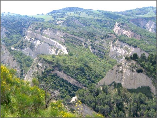 |
Figure 4. Mediterranean pine afforestation in Calanchi badlands near Aliano in the Matera study site. Source: (Author Giuseppe Mancino). |
In some areas it is possible to find other species, in particular eucalyptus (Eucalyptus spp.) and cypresses (Cupressus sempervirens and Cupressus arizonica). The Mediterranean pine forest type includes both artificial populations and natural populations of Aleppo pine representing 5.5 percent of the Basilicata Region forest cover. The environmental sensitivity to desertification risk of these formations is sufficiently elevated (mean ESAI value equal to 1.32) as testified by sub-optimal vegetation and phytosanitary conditions. These conditions are also due to environmental constraints (scarce rainfall, elevated summer temperatures, extended periods of drought, bad edaphic conditions) and human pressure. High fire frequency is an issue, due to intense agricultural activities in the adjacent areas, meteorological conditions that favour ignition and grazing that often exceeds the capacities of these top-soils.
The last forest type is represented by shrublands, in particular the natural and semi-natural Mediterranean macchia and garrigue that are subjected to strong environmental pressures and alterations in the Basilicata region. The extent of Mediterranean macchia in Basilicata represents 7.9 percent of the total forest area of the region. This vegetation cover is typical of the Mediterranean basin. Plants in this forest type are adapted to the particular climatic conditions, high temperatures and low rainfall, which limit the number of species living in this area. The forest physiognomy is characterised by broadleaf evergreen trees and bushes, such as the Holm oak, and principally rock roses, lentisk, myrtle and rosemary. The garrigue is typically represented by rock roses, lentisk and rosemary and covers about 5.923 ha of the Basilicata Region (1.7 percent of the total surface), distributed in the territory near Matera along the Ionian coastal zone.
The garrigue represents a particular association between shrub and herbaceous species of Mediterranean plants, from sea level to 1400m. Its presence is related to degraded conditions of rocky, steep and arid soils, where excessive grazing and repeated harvest felling, accompanied by frequent, often annual use of fire to stimulate grass re-growth, has prevented forest evolution. The main types of species are geophytes and sclerophylls, characterized by hard leaves and the thorns and they are adapted to cope with livestock grazing and long periods of aridity. Due to the discontinuity of its cover, the garrigue is a susceptible ecosystem and vulnerable to degradation and desertification in Mediterranean environments.