Forests & shrubland
Characteristics of forests & shrubland: Spain, Portugal and Baixo Guadiana
Editor's note: Text extracted from D311-2.3
Characteristics of forests & shrubland in Spain
Spain’s climatic and lithological heterogeneity has helped to create a highly compartmentalised territory, which in turn has brought about a variety of vegetation and landscape types, from forests similar to those of Atlantic Europe up to and including sub-desert steppe and subtropical plant formations. The modern landscape of Spain is a mosaic in which natural woodland, brushwood and herbaceous formations, along with farming and reforested areas, are unevenly distributed throughout the territory. This variety of landscapes finds its main expression in a rich flora consisting of over 26,500 taxa; 8,000 of which are vascular plants (EEA SOERa 2010). The definitions of forest differ among countries and institutions. For instance, the percentage of tree cover is an indicator that is used to define what a forest is. These differences in definitions also lead to different information of how much area is classified as Forest. According to FAO, the forest area in Spain is 14.4 million hectares, making it the fourth biggest country in Europe in terms of forest resources. Forests occupy almost 29 percent of the total land area and this figure is increasing by about 86,000 ha per year. The growth of forest cover has been through natural expansion and through a forest plantation programme which has been operating for more than 50 years, with soil protection and erosion prevention as its main aims (FAO 2011). Spain has received funds from the European Union in support of this program (http://www.fao.org/forestry/country/57478/en/esp/). According to the Spanish definition of a forest, the ’Ministry of Environment , rural and marine affairs´ (Ministerio de Medio Ambiente y medio Rural y Marino) defines 27.6 million ha as an extensive forest (wooded) area. The extensive forest contains a large number of agricultural, forest and transitional ecosystems that have emerged as a result of human activity within the natural environment (MARM 2011).
The most productive forests are found in the Atlantic coastal zone and are composed primarily of pines (Pinus pinaster and P. radiata) and eucalyptus (Eucalyptus globulus), although some mixed natural forests of oak (Quercus robur and Q. patraea) and beech (Fagus sylvatica) are also found. In the Pyrenees, there are forests of silver fir (Abies alba), beech and pine, depending on altitude. The remainder of the country, where Mediterranean conditions predominate, is notable for its wealth of biological diversity. In some places Quercus spp. are found in pure stands, constituting wooded meadows (an agro-silvo-pastoral combination typical of Mediterranean zones) or mixed with pines and a wide variety of shrubs and scrub vegetation. In mountainous Mediterranean regions Pinus spp. becomes increasingly frequent as the altitude increases (FAO 2011).
Sixty-six percent of forest lands belong to approximately two million owners, 30 percent to municipalities and only four percent to the autonomous communities. However, most municipal forests are public service forests (a special forest protection legal category dating back to 1850) and these forests are managed by the autonomous communities. About 25 percent of forests are classified as protected areas. The main function of 88 percent of Spanish forests is to protect the soil against erosion and desertification and to regulate the hydrological cycle, in a country with steep slopes and scant, irregular rainfall. The remaining 12 percent are mainly production forests, which produce 80 percent of the total supply of roundwood. Non-wood forest products such as cork, gum and medicinal and aromatic plants are also important. Other non-wood forest products and services include hunting, fodder, nuts, fruit and truffles. Landscape aesthetic value, tourism, leisure and recreation are increasingly important uses of forests in Mediterranean zones (FAO 2011).
The administrative organization of Spain is decentralized. The Autonomous Communities and cities take on the environmental competences which have been transferred to them, and so they play a decisive role in the definition and implementation of environmental policies in close coordination with the General State Administration. Each of these Autonomous Communities has a competent organization for environmental matters and has the ability to create their own Environmental Agency or similar institutions. There are 17 Autonomous Communities and two Autonomous Cities.
Spain has two clearly defined types of protected natural areas: Protected Natural Areas (designated under Law 42/2007, on Natural Heritage and Biodiversity) and protection granted by inclusion in the Natura 2000 network. Spain's protected natural areas also include those covered by international agreements, such as Wetlands of International Importance (designated under the Ramsar Convention) and Biosphere Reserves. As far as biodiversity protection is concerned, attention must be drawn to the important effort made by Spain. In 2009, 27.65 percent of the whole of Spanish territory was under protection, either by having been declared as Protected Natural Areas (PNA) or through its inclusion in the Natura 2000 Network. The number of PNAs is 1,519 encompassing a total area (terrestrial as well as marine of 6,174,788 hectares. The Sites of Community Importance (SCI), both on land and on the sea, amount to 1,435 while the number of Bird Special Protection Areas (BSPA) stands at 594. In this regard, the great importance of numerous Spanish spots for bird migration between Africa and Europe must be highlighted. Such an effort for the protection of biodiversity has been acknowledged by the UNESCO MAB programme, since Spain is the third country in the world (after the United States and the Russian Federation) in terms of numbers of Biosphere Reserves (EEA SOERa 2010).
Characteristics of forests & shrubland in Portugal
Land use changes have modified the Portuguese landscape, ecosystems and environment. Urban areas consume significant quantities of resources at the expense of agricultural lands. Rural landscapes are also undergoing change, with intensification of farming and forestry activity on one hand, and abandonment of the land, on the other (EEA SOERc 2010). Land use change mapping activities carried out between 2000 and 2006 reveal that during this short period of time, approximately 8.6 percent of the land area was modified. These modifications include the expansion of artificial surfaces, such as roads and buildings (an increase of 10 percent or 28,000 hectares), construction of dams (in particular, the Alqueva dam and the extension of its influence) and the conversion of agricultural areas into areas with natural vegetation and vice-versa (APA 2009). In 2006, 71 percent of continental Portugal consisted of forest and agricultural land and approximately 15 percent was a mixture of agricultural land use and natural areas. Artificial surfaces represented 3.5 percent and natural vegetation took up 8.6 percent of land cover (IGP 2009). In spite of land use changes, the overall distribution remains comparable to that registered in 2000. Forests and areas of natural vegetation continue to dominate land cover in continental Portugal and remain the focus of the most dynamic changes.
Afforestation is shaping the landscape, mainly in the centre of the country. The trees used for afforestation are mainly fast growing tree species such as eucalyptus (EEA SOERc 2010). A contributing factor to the changes occurring in this land use sector are the numerous forest fires which affect the country every year and have a significant impact on the landscape and land cover. Although forest areas have been converted to other uses, new forests have also been planted. Between 2000 and 2006, there was a net increase of 30,000 hectares of forest cover. In contrast, areas covered by natural vegetation declined by 27,000 hectares or 3.5 percent (APA 2009). Between 2000 and 2006, over 28,000 hectares of agricultural, forest and other semi-natural and natural land was converted to urban areas and other artificial developments. Exactly 50 percent of that amount was taken from forests and 40 percent from agriculture.
Characteristics of forests & shrubland in the Baixo Guadiana study site
The study site area Baixo Guadiana lies in the lower Guadiana Basin, which is situated at the south western part of Iberia (Figure 1) at the border between Spain and Portugal.
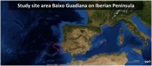 |
Figure 1. The study site area on the Iberian Peninsula. Source: (Author Michiel Curfs) |
The Baixo Guadiana represents and summarizes most of the aspects and characteristics of the Mediterranean areas, with a high severity of climate, environment and socio-economic features. The area has the marked characteristics of Mediterranean climate with long, dry periods and high temperatures during summer, associated with a trend of decreasing average annual rainfall that falls in irregular showers. This has negative influences on the ecophysiological efficiency of forests and their phytosanitary status, and can trigger increasing erosion rates. The Baixo Guadiana is a rural area with low population density in the interior and higher population density in the coastal zone. The lack of development opportunities in the interior area has led, and still leads to, unemployment. This is a cause of the negative demographic trend with consequences on the age structure of the population, causing a gradual shift in demographics from younger classes to the elderly. An ageing population structure is a common phenomenon in the interior municipalities. Depopulation is pronounced in the interior parts of the study area. The decline in population is a phenomenon found in almost all municipalities in the Baixo Guadiana however, the coastal municipalities show an increase in population. Littoralisation can clearly be observed in the Baixo Guadiana area. The positive demographic trends in the coastal zone are related to the fact that the coastal municipalities are the most socio-economically vital areas of the Baixo Guadiana, with tourism being the most important activity.
Shrubs and herbaceous cover are the main land use form, representing 42 percent of the total territory of the international Lower Guadiana area. Thirty five percent of the territory in the Lower Guadiana area has undergone changes in land use between 1990 and 2006 (Figure 2).
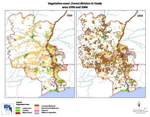 |
Figure 2. Vegetation cover of the Forest divisions in the Baixo Guadiana area in 1990 and in 2006. Source: (Adapted from Felicidades Garcia 2010) |
Nearly 30,000 hectares of farmland have become forested areas, of which 20,500 ha have become agro-forestry. The forest area has increased by approximately 16,000 ha in 16 years, but this increase masks a much larger transformation, which is the radical change in floristic composition (Figure 3). This change can be summarised as follows: The forest surface has decreased by 30 percent, a decrease in area of approximately 4,500 ha. There is a more evident decrease in the matorral without trees areas. This division has decreased by 50 percent. However, there has been a large increase in area of the division of matorral with trees. This has increased by 583 percent from 1990 to 2006, an increase in area of nearly 70,000ha (Felicidades Garcia 2010). This last division, the matorral with trees, can be described as young dehesas and montados; the trees that are planted consist mainly of Holm oak.
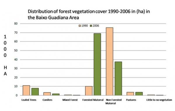 |
Figure 3. Distribution of forest vegetation cover in the forest division. Source: (Adapted from Felicidades Garcia 2010) |
Dehesas and montados with its Holm oak (Quercus ilex) and Cork oak (Quercus suber), constitutes the largest forest type in the geological Pyrite belt area, and more generally in the whole of the Mediterranean forests (Figure 4).
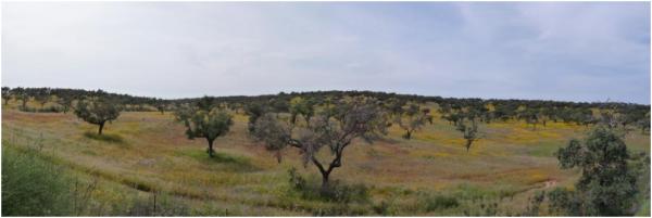 |
Figure 4. The Dehesa in the Baixo Guadiana in April. Source: (Author Michiel Curfs) |
Dehesas and montados are forest areas in which the distance between trees should be kept at a density which is in equilibrium with its land use, in that they are forests that allow development and use of pasture by livestock grazers. The conservation of this type of forest is related to its economic functions, which are critical to the profitability of the system. The density of trees should meet the requirements for natural light of grassland, and also facilitate the movement of livestock (Olea and Miguel-Ayanz 2006).