Soil water availability
In the last decades several numerical hydrologic models has been developed to answer to the questions related to the water resource availability in forested soils due to the impacts that have on forest growth and management. In this ambit it is possible to evaluate a soil moisture index through the hydrological model used by several authors (Coops et al., 2005; Coops and Waring, 2001a; Coops and Waring, 2001b; Waring and Running, 2007).
| Aim of the method/technique |
The soil moisture index provides assessments of the water available in forest soil both over space and time.
|
| Scale – spatial and temporal |
The model has been originally designed for site specific applications, but due to its simple modelling approach it has been modified and implemented in a GIS environment from local to regional scale with a variable temporal resolution from days to years.
|
| Brief description |
To assess the soil moisture the model integrates a simplified physiological based hydrological balance routine, implemented in a GIS environment. In particular the model assesses the soil water availability represented by a soil moisture index, as the difference between monthly evapotranspiration and monthly precipitation starting from the simple Penman-Monteith approach, Landsberg & Waring, (1997). The water balance model is parameterized as a function of the main ecosystem characteristics involved in the main processes as edaphic features (soil texture and depth), forest types and forest cover, land use and leaf area index (LAI). According to this methodological approach the model can be implemented at different scale and vegetation types by introducing modified Penman-Monteith functions to assess evapotranspiration for different vegetation types. In figure 8 an example of soil moisture estimate is reported.
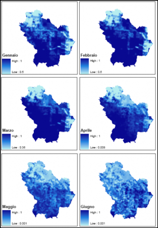 |
Monthly estimate of soil moisture in Basilicata Region (Source: Nolè et al., 2008) |
|
| Data requirements |
The model routine requires daily meteorological data:
- Precipitation (mm)
- Maximum air temperature (°C)
- Minimum air temperature (°C)
- Relative humidity (%)
- Soil temperature, ave. 24-h (°C)
- Short-wave radiation (kJ m-² day-¹)
- Leaf area index (m² m-²)
- Daylight average air temperature (°C)
- Average night minimum temperature (°C)
- Vapor pressure deficit (mbar)
- Absolute humidity deficit (g m-³)
- Daylength (s)
- Canopy daily average radiation (kJ m-² day-¹)
|
| Main applications in forests & shrubland regions |
The model has been applied over a wide range of forest types in North America, New Zealand, Australia and Europe as subroutine to assess the soil moisture of forest stands in a wider framework of ecosystem productivity assessment (Coops and Waring 2001a, 2001b; Coops et al. 2001, 2005; Law et al., 2000; Sands and Landsberg, 2002; Tickle et al. 2001; Xenakis et al., 2008), including the Italian forest systems for the desertnet (Nolè et al., 2008, 2009).
|
| Strengths and weaknesses |
Strengths:
- High flexibility in temporal scale and coverage, ranging from days to millennia
- Flexible in spatial coverage, ranging from single site-specific application to regional scale
- Provide crucial links between biophysical conditions and human activities, especially crops and forestry
Weaknesses:
- Some ecological functions request the use of empirical formulations
- Site-specific parameterisation
- Availability of spatial input information
|