Multimedia
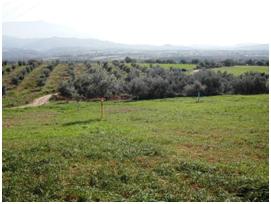
Development area
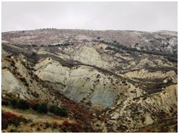
Geomorphology
| Aim of the method/technique | The aim of geomorphology mapping is to present the surface characteristics of landforms by combining slope gradient, hypsometry, and degree of dissection by various streams. The description of the various geomorphologic characteristics requires direct land observations, as well as existing data or models such as Digital Elevation Model (DEM) (Wood 1996), and satellite images (Fornaciai et al. 2008). Using geomorphology characteristics of an area, it is possible to define the origin of land features and provide information on their possible evolution, through the geomorphological studies such as the nature of the rocks in which they are modelled (lithological study), the geometric relationships between layers of rock formations or packages of different types (stratigraphic study), the bedding of the layers and the presence of fractures, faults, sliding surfaces, etc. (Structural study). |
||||
| Scale – spatial and temporal | A geomorphology map is usually presented on a large scale usually 1:50,000, or better a scale 1:5,000. At European level, there is a DEM with pixel resolution of 1km*1km of the EEA (European Environment Agency), derived from GTOPO30, produced by the USGS for the entire globe through the mission SRTM (Shuttle Radar Topography Mission). Recently, the NASA mission "ASTER Global Digital Elevation Model" led to the creation of a DEM with 30 m*30 m resolution covering 99% of the Earth's surface. For the Italian regions it is available a DEM with a resolution of 20 m*20 m, made by the Ministry of Environment, obtained by the interpolation techniques of contour lines and elevation points (Tarquini et al. 2007). Data have low temporal variability. There is low temporal change on geomorphologic characteristics of an area considering periods of decades or even centuries. Spatial change of geomorphology is greatly affected by land characteristics such as topography, dissection, and geology. |
||||
| Brief description | Geomorphology can be described based on the morphology of land forms and not by their genetic origin or processes responsible for their shape (Engelen and Wen 1995). According to Engelen and Wen (1995), the following geomorphologic landforms are distinguished that are suitable for scales smaller than 1:100,000:
|
||||
| Data requirements | Landforms can be distinguished in the field by observing slope gradient and relief differences between lower and highest point expressed in meters per specified distance, and degree of land dissection. Data required are topographic maps or better Digital Elevation Models, aerial photographs or satellite images. | ||||
| Main applications in cropland and forests & shrubland regions | Geomorphology or landforms are used in assessing land degradation processes such as soil salinization, soil erosion and deposition; mass movement; soil characteristics affecting crop production such as soil drainage, soil texture; type of ecosystems, etc. Geomorphological information is directly used as input information in risk of land degradation assessment models such as the model ESA (Environmental Sensitive Areas) (Kosmas et al. 1999). Some geomorphology parameters, such as slope length and slope steepness are used in the USLE model (Wischmeier & Smith 1978) to identify the risk of erosion can be obtained through processing of DEM. The morphometric data are also input layers of PESERA model (Kirkby et al. 2004), a physically based model for identifying the erosion risk (Irvine & Kosmas 2004). |
||||
| Strengths and weaknesses | Some of the weaknesses of geomorphology mapping are related to the lack of uniformity of existing classification systems. Furthermore, geomorphology mapping requires many field observations by geomorphologists. Also, the main limitations of the available geomorphological information are currently due to the unavailability of uniform datasets at various scales (from global to local) and their standards of representation. Another limitation is the lack, in some cases, of digital geo-referenced mapping supports. |