Home
Responses to LEDD
Cropland
Grazing land
Forests & shrubland
Study sites
Policy context
Multimedia
17th June
Login
Home
Western Andévalo, Spain
Western Andévalo SES
Hydrological network
Multimedia
Video Gallery
References
Glossary
Photo gallery
Download documents
Development area
SES parameters
Development area
Editor & Partner login
User Name
Password
Remember Me
Forgot your password?
Forgot your username?
Hydrological network
Views: 27
Return to the gallery
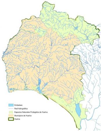
Description: Hydrological network map and water bodies. Source: Junta de Andalucia, 2010
Powered by
FW_GALLERY
2014-11-28 11:13:50