Home
Responses to LEDD
Cropland
Grazing land
Forests & shrubland
Study sites
Policy context
Multimedia
17th June
Login
Home
Messara Valley, Crete
Protoria Community
Soil erosion map
Multimedia
Video Gallery
References
Glossary
Photo gallery
Download documents
Development area
SES parameters
Development area
Editor & Partner login
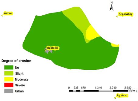
User Name
Password
Remember Me
Forgot your password?
Forgot your username?
Soil erosion map
Views: 31
Return to the gallery
Description: Spatial distribution of degree of soil erosion existing in the area of Protoria community. Source: (LEDDRA project)
Powered by
FW_GALLERY
2014-11-28 11:11:03