Study sites in cropland
Study sites in grazing land
Study sites in forests
General description of Matera SES
Editor's note 8Mar13. Source D331-2.3.
| Authors: | Agostino Ferrara & Giovanni Quaranta |
| Contributing Authors: | Sofia Bajocco, Antonella De Angelis, Giuseppe Mancino, Alberto Mancini, Francesco Ripullone, Luca Salvati, Rosanna Salvia |
| Editors: | Alexandros Kandelapas, Vassilis Koutsoukos, Jane Brandt |
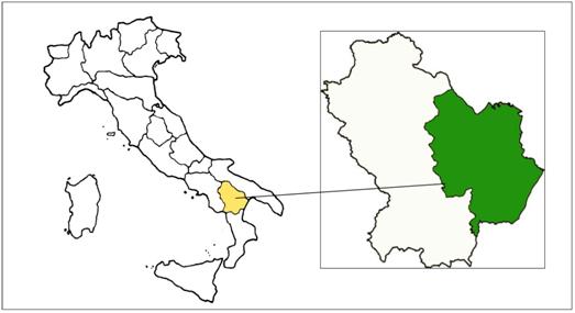 |
Location The Matera prefecture study site covers an area of 343,362 ha, distributed among 31 municipalities. The town of Matera is the largest municipality (38,000 ha), followed by four municipalities that extending to over 20,000 ha. The most densely populated areas are located along the Ionian coast. |
Climate
From 2005 to 2010, the mean value of precipitation was 669.13mm. Annual mean temperature is generally between 14 and 15 °C. The rainiest months are March, September and December, while May and August are the driest. The temperature peak is registered in July with mean value around 25 °C. Mean annual ET0 values vary from 1131.25 mm in the South-West to 1478.77 mm in the North-West.
Topography, geology, soils and hydrology
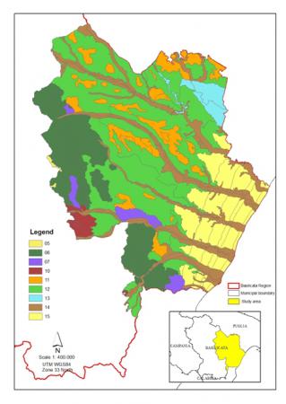
The province has well defined orographic features and hydrographic network structure. It may be divided into altimetric zones, with different morphology and vegetation. The Apennine side includes mountain ridges, the hilly area and large plains. The most common geolithogical formations are clay formations (34%) and alluvial deposits (29%).
The Ionian coast is characterised by a wide plain and a flat coastal strip, exhibiting a sequence of sand dune ridges, followed by a wide alluvial plain and marine terraces as one moves further inland.
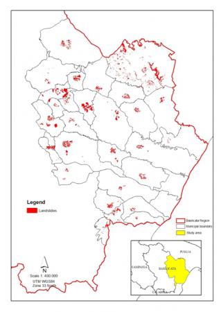
Dominant aspect classes are 10-25% (33% of the area) and 0-5% (31%). Slopes are characterized by smooth hills, with weak to moderate slopes, subjected to laminar erosion and mudflows. Landslides are a widespread phenomenon, affecting more than 7,500 ha.
|
|
 |
 |
Types of soil in the area are "Soils of the clay hills" (38%), "Soils of the central rough mountains" (17%), "Soils of the alluvial plains" (16%), and "Soils of the Ionian coastal plain" (13%). Soil textures are moderately fine (35%), fine (34%), medium (15%) and coarse (15%). In 69% of Matera, soil reaction is moderately alkaline. Soil carbonate content is mostly very calcareous (47%), non calcareous (26%) and moderately calcareous (21.3%). Almost 70,000 ha, mainly in the intensively cultivated Ionian coast are affected by nitrate pollution risk as a consequence of intensive agriculture and low purifying capacity of soils. Generally Matera is under moderate erosion risk, with low levels at the forest cover and higher levels of risk corresponding to the "calanchi" areas.
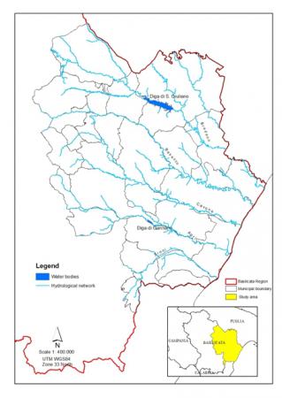
Matera is crossed by all the major rivers of Basilicata.
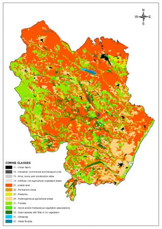
Ecosystems and land use
Ecosystems in the area in include cultivated areas and forests. Vegetation is dominated by the Lauretum (i.e. formations with predominance of Laurum nobilis) and in some areas in the west by the Castanetum (chestnut formations) and the Fagetum (beech formations).
 |
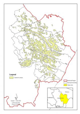 |
The study area includes several natural reserves including 13 Sites of Community interest and the Pollino National Park. The dominant land cover classes are arable land (47%), forests (16%), heterogeneous agricultural areas (16%), permanent crops (7%), shrub (6%) and pastures (2%). A significant part of Matera (68,444 ha) is covered by the calanchi badlands a typical Matera landscape, with different degrees of erosion starting from simple laminar erosion to the "biancane", small rounded residual hills. Calanchia areas are the result of typical erosion form distributed in the Italian Apennines.
Land use is mainly cropland (55%), forests (10%), wood plantations (13%) and pastures (16%) Land use structure has changed significantly in the last twenty years, having undergone an urbanization process: artificial areas more than doubled since 1990. Agricultural land is generally privately owned.
Population, employment and income
Population is concentrated in the municipality of Matera with a resident population over the 20,000 inhabitants. All other municipalities have between 1,000 and 10,000 inhabitants, with three communitied having less than 1,000. Population density is generally between 21 and 50 inhabitants per km², except in four municipalities where it exceeds 100. Population was growing until 1991, and has declined by almost 3% since. The elderly people account for an increasing share of the population. The total dependency ratio is around the threshold value of 50%. Matera's birth rate remains higher than the regional average and, until 2003, was higher than the national average. Net migration flow is negative: internal migration counteracts incoming immigrants coming from third countries.
Economically, only the tertiary sector is growing, while industry and agriculture show fluctuating trends. Trade balance in Matera Prefecture is positive. Annual new investments, since 1995 fluctuate around 2,000,000€, concentrated in services and industry. Location quotients indicate self-sufficiency for industrial and agricultural production but not for services.
The dominant source of employment is trade and services (57%, up from 28% in 1971), followed by industry (29%). Agricultural employment decreased from 37% in 1971, to 14%. Unemployment is steadily over 9% (almost 14% in 2004) and over the Italian national average. 99% of the population is literate and HDI is 91.16.
Administration and infrastructure
Administratively, Matera is one of the two prefectures of the region of Basilicata.
Matera Prefecture is crossed by an extensive road network (1720 km) and the railroad (128 km). The area hosts 3 hospitals (down from 5 in 2001), 87 nursery schools, 60 primary schools, 32 lower and 36 upper secondary schools, as well as 4 museums (visitors exceeding 60,000 annually).
Policies in effect
With regard to forests/ shrubland, there is no specific national policy or legislation to combat drought and desertification. However, the general legislative framework does include the protection and valorisation of environmental resources.
Prevention and mitigation of forest fires has a concise legal framework as does the sustainable development and management of the forest sector. However, regional forest laws, contain few references to the risk of desertification, despite its occurrence and impacts in the center-south regions. Nevertheless, general risk prevention through rational management of forest resources, such as hydro-geological risks or forest fires, is prevalent. The agricultural sector is also heavily regulated, more recently by Legislative Decree 101/2005, aiming at the sector's modernization.
At regional and study site level, the forestry and agricultural sectors are primarily addressed by the Rural Development Programme of Basilicata (2007-2013) and Regional Law 42/1998 defining rural development measures. Grazing, forest management , forest fire prevention and wildlife conservation are regulated by decrees of the Regional Council. Basilicata also has a Regional Energy and Environment Plan (Piear), covering among others, renewable energy sources from agriculture and forestry.
Particular LEDD issues in Matera
- Forest productivity decline, as a response to the loss in the ability of soils to retain nutrients and to a decline in soil water storage capability by the ecosystem. It is caused by various human induced factors including forest fragmentation, poor harvesting and management practices and overgrazing. Forest fires and wild fires are also common and have significant effects with regard to soil erosion, forest fragmentation and biodiversity loss, generally inducing land degradation processes. From 1990 to 2004, 1584 fires broke out affecting a total surface of 581,49ha (42% forest, 58% non-forest), primarily in the municipalities of Tursi, Miglionico, Stigliano and Pomarico.The increase in the frequency of extreme climatic events is the principal abiotic factor for long-term processes of forest and shrubland productivity decline.
- Biodiversity loss, driven by forest fires, overgrazing, habitat change, pollution, invasive alien species, tourism and climate change.
- Ecosystem fragmentation as the result of direct loss of forest area by wildfires, but also of "edge effects" of anthropogenic land uses (urban, touristic or agriculture). In general these processes produce relictual ecosystems with the transformation of a healthy forest into a monoculture for timber, leaving only isolated historical remnants of native vegetation.
- Soil erosion, caused by the clearance of maquis for agricultural expansion, changes in plant cover due to intensive cultivation, over-grazing, controlled burning or wildfires, levelling of the land surface, plowing in directions perpendicular to the contour lines, poor maintenance of terracing land, cultivation of steep slopes and others. Repeated forest fires have been particularly destructive, leading to an involution in the forest succession stages, a lowering of the amount of biomass and increasing the risk of erosion, deterioration of chemical and physical characteristics and landslides. Alterations of soil characteristics involve changes in porosity (reduction in soil ventilation and infiltration capacity), reduction in organic matter content, and the development of a waterproof layer to a depth of 10-15 cm. Post fire grazing leads to a further reduction in tree cover. In the Calanchi area, microtopography (slope, aspect) is a key factor affecting soil erosion rate.
- Water stress and phytosanitary deterioration, brought about by extreme climatic events, affect primarily for coastal pinewood forest and coniferous reforestation in Calanchi area.
- Land degradation and desertification as the result of the combined pressures posed by the increasing frequency of extreme climatic events, ecosystem overexploitation and in some cases land abandonment. Land overexploitation is generally driven by unsustainable agricultural and grazing practices. Land abandonment is generally driven by socio-economic factors (property fragmentation, low agricultural incomes etc). In this context, extreme weather accelerates physical and biological processes at the base of main LEDD issues.
Responses made to LEDD in Matera
- The main response to forest productivity decline is the sustainable forest management, through Forest Management Plans, analysing soil and vegetation characteristics to better define the sustainability of their use.
- Regional measures for biodiversity monitoring and protection are also in place.
- Ecosystem fragmentation is addressed at the regional level, through the Triennial Forestation Plan and the Triennial Fire Protection Plan (measures include the maintenance of firebreaks, maintenance of forest roads, stand cleanings and thinnings, renaturalization practices for reforested areas and the creation of ecological corridors).
- With regard to soil erosion, the Basilicata Region administration has put in place the "Regional programme for combating drought and desertification", which foresees the sustainable management and improvement of regional forest areas, slope protection with naturalistic engineering, support for sustainable agriculture and water resource management
- Water stress and phytosanitary deterioration are also addressed through forest management plans and primarily through the Triennial Plan of Forestation of the Basilicata Region. Specific measures include: the reconstitution of degraded forests; reforestation and re-naturalization and direct actions against processionary and scolytus outbreaks (phytosanitary thinning and burning of processionary nest)
- In the context of the UN Convention to Combat Desertification, the Basilicata Region (Dept. of Environment, Land and Sustainability Policy) has put in place a Regional Programme to combat drought and desertification and participates in several projects for monitoring, awareness raising, consultation and coordination of local authorities and institutions.