Study sites in cropland
Study sites in grazing land
Study sites in forests
General description of Messara Valley SES
| Authors: | Constantinos Kosmas, Mina Karamesouti, Thanasis Kizos, Katerina Kounalaki, Minas Metaxakis |
| Editors: | Alexandros Kandelapas, Vassilis Koutsoukos, Jane Brandt |
Editor's note 26Nov2012. Content source: D131-2.3
Location
 |
The Messara valley is located in the central-southern part of Crete, about 50 km south of the city of Heraklion and constitutes the most important agricultural region of the island. While, the hilly and mountainous areas of the valley were covered with forest in the past, most of these forests are now cultivated with olives, vines, vegetable, fruit and cereals. Groundwater is a very important resource affecting crop production and the local economy. |
Climate
|
|
|
|
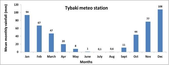
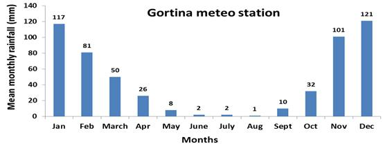
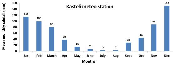
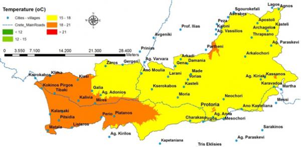
Messara valley is characterised by dry sub-humid climate with mild moist winters and dry hot summers. Average annual rainfall ranges from 750 to 1000 mm. Potential evapotranspiration in the Valley ranges from 1481 mm to 1549 mm yr-¹. The eastern part of the valley has the lowest ETo values. |
Topography and soils
|
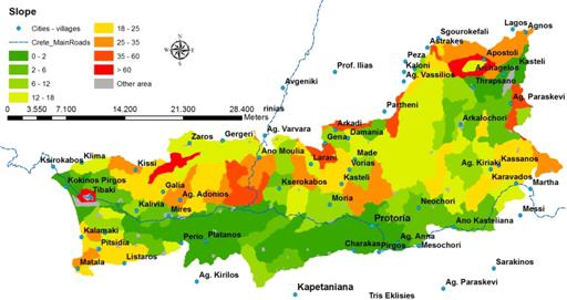
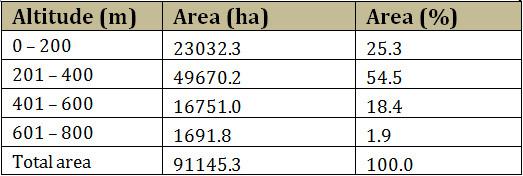
Altitude in the Messara valley is lower than 400m and a large part (39%) is characterised as almost flat. Major types of landforms are composite landforms (36.4%), level land (39.5%) and sloping land (22.4%). |
 |
Geology
Geologically the valley is characterised by marl deposits (49.6% of the area, mainly cultivated with olives) and alluvial deposits (23.3%) which are the most productive soils intensively cultivated with olives, vegetables, and citrus. Due to the low rainfall in the area the soils are well/moderately well drained. The soils formed on residual parent materials classified mainly as Cambisols (76.4% of the total area) are characterized by their advanced degree of erosion. The agricultural potential of these soils present limitations due to sloping terrain, shallow to moderate soil depth, moderate fertility and excessive drought during the dry season.
| Soil texture throughout the valley is mainly characterized as moderately fine. The lowland is mainly characterized by deep and very deep soils. The surrounding hilly area of the valley is characterized mainly by moderately deep and moderately shallow soils. Rock fragments content in the soil surface varies. Soil drainage is clearly related to the topography of the valley while very well drained soils is the major class of soil drainage (74.1% of the area). | 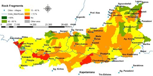 |
Hydrology
|
|
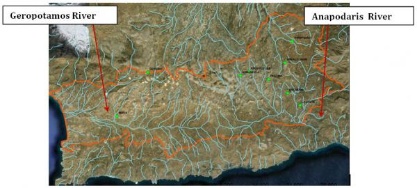
Based on the hydrological boundaries and land use, the valley comprises of two main catchments: the western Messara catchment area (the Geropotamos River discharging near Phaestos) and the eastern Messara catchment area (the Anapodaris River discharging near Demati area). Water flow in Geropotamos is estimated at 14 million m³ per year and the river remains almost dry during the summer period. Anapodaris is the longest river in Crete, discharging about 40 million m³ per year. The main source of irrigation water in Messara Valley is groundwater. Nine main water reservoirs have been identified in the study area, with a total water storage capacity of approximately 25 million m³. The Faneromeni irrigation water reservoir, has a capacity of 19,670,000 m³. |
Ecosystem
|
|
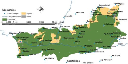
The Messara Valley is predominantly a cultivated ecosystem: 64.6% of the area is covered by olive groves. Small parts in of the lower and western part are characterized for their unique biodiversity (2.0% of the total area). |
Population
|
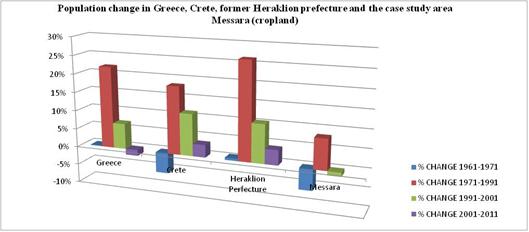
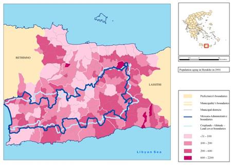
Population in Messara over the last 50 years has remained relatively stable, exhibiting, however, a 2% decrease since 1991, which may be partly explained by migration towards the urban center of Heraklion. While population density in Messara, including the communities of Gagales and Protoria, has generally increased, the wide base of the population pyramids in 1960s and 1970s has been replaced by a broadening of the upper age classes in the pyramid. Decreasing birth rates and rising levels of life expectancy for both sexes coupled with the return of the migrants in the 1990s. |
Population ageing in Messara and the communities of Gagales and Protoria is more severe than in the former Heraklion prefecture and Crete in general. |
Employment
Farming is the main source of employment (27,4%) followed by commerce and repairs (14%) and manufacture (8,3%). Unemployment rate in the study area has doubled since 1991 although it remains of the lowest nationally.
The Union of the Agricultural Cooperatives of Messara (EAS Messara) is union of 46 local cooperatives with more than 15.000 members. In addition, the 2nd degree cooperative, the union of Agricultural Cooperatives of Heraklion (AGRUNION), is one of the larger agricultural cooperatives in Greece. The Agricultural Cooperatives of Peza (PUC) specialising in wine and olive oil is also active in the area.
Local administration
The administrative structure is evolving, having undergone two major reforms in the last 15 years. Currently, the head of the Region is elected for a four year term and the region incorporates the four regional units (former prefectures) of Chania, Rethymnon, Heraklion and Lassithi. The city of Heraklion (the capital of the prefectural area), is the seat of the majority of the financial and administrative services and offices of the island.
Messara is located in the central part of the former Heraklion prefecture and includes the municipalities of Phaistos and Gortynas (east), Archanes-Asterousia and Minoa Pediados (west) and Asterousia (south). The study includes 72 mostly flat municipal districts which until 1997 were self-governed municipalities or communities.
Infrastructure
Heraklion has an extensive road network divided in primary roads (European and regional), secondary roads (prefectural) and in tertiary roads (local and rural). Systems of optical fibers have been installed along the northern coastline of the island in order to support the high-speed avenues of communications. Generally, the telecommunication services supplied are held by the central connection stations of Hellenic Telecommunications Organization (OTE).
|
|
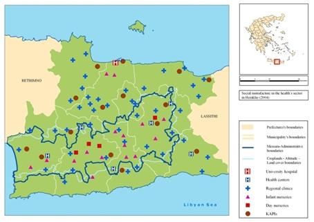
Education, health and social infrastructure is deemed adequate having undergone significant expansion during the last decade, primarily through the European Social Fund. The area is also serviced by the city of Heraklion. Infant and day care facilities operate in all municipalities. Several municipalities and the church operate facilities for the elderly including homes, day care centers (KIFIs) and services to the elderly at home. Family ties are also crucial for the support of the elderly. |
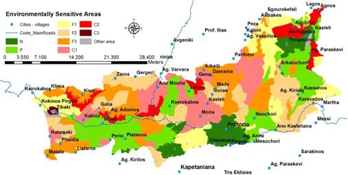
LEDD issues in Messara valley
|
The most important LEDD problems in Messara Valley are:
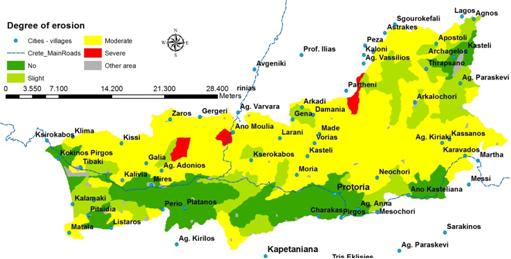
All of the above interrelated issues lead to land degradation and desertification. Critical areas to desertification cover 21.2% of the Valley, although the majority of these areas are not in extreme risk of desertification. |
|