Home
Responses to LEDD
Cropland
Grazing land
Forests & shrubland
Study sites
Policy context
Multimedia
17th June
Login
Home
Canyoles River Basin, Spain
Montesa Community
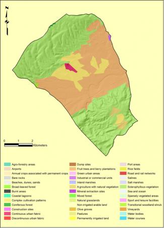
CORINE land cover map
Multimedia
Video Gallery
References
Glossary
Photo gallery
Download documents
Development area
SES parameters
Development area
Editor & Partner login
User Name
Password
Remember Me
Forgot your password?
Forgot your username?
CORINE land cover map
Views: 22
Return to the gallery
Description: CORINE Land Cover, 2006
Powered by
FW_GALLERY
2014-11-28 11:12:00