Rainfall
Rainfall is a basic component of climatic characteristics of an area. Rainfall characteristics of an area for the purpose of this project are: (a) graphs of daily and monthly rainfall, (b) graphs of mean monthly rainfall change with time including standard deviation values.
| Aim of the method /technique |
The method aims to describe: (a) the detail change of rainfall year by year, (b) the monthly rainfall change with time within hydrological year, and (c) the average monthly rainfall with time in years. |
| Scale – spatial and temporal |
Rainfall data are based on point observations (meteorological stations). The link with landscape characteristics requires the assessment of the geographical area covered by each meteorological station. Thiessen polygons can be used for regionalization of point rainfall data. Thiessen network can be corrected taking into consideration topographic features. A period of at least 30 years is necessary to describe the prevailing amount of rainfall in a study area. |
| Brief description |
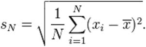
Average values of rainfall for a certain period are calculated by the equation given above. Deviation (SN) of rainfall per month or year is calculated by the following equation (Steel et al., 1997):
Monthly rainfall can be plotted in the same graph with monthly air temperature for deriving the umbrothermic diagram. For drawing this diagram, time is plotted in the x-axis in months, the left y-axis indicates rainfall in mm, and the right y-axis indicates air temperature. The precipitation scale must be twice the scale of air temperature. The area in which air temperature curve is above rainfall curve gives the Bagnouls-Gaussen aridity index.
|
| Data requirements |
Longitudinal daily or monthly data are required. Such data are provided by the regional or national Meteorological Services or the regional administration. |
| Main applications in cropland and forests & shrubland regions |
Rainfall change with time and average values for an cropland region are basic characteristics for natural resources inventory and ecosystem performance such as plant growth, soil water balance, soil erosion, land desertification, ecosystem resilience, biodiversity, etc.
|
| Strengths and weaknesses |
The proposed method includes standard basic statistical analysis used for biological studies. The main weakness of the proposed method is usually attributed to the availability of raw data required for the analysis. |